Trail Walking Moras - Moras - Photo
© OpenStreetMap contributors
Length
Length
19 km
Max alt
Max alt
406 m
Uphill gradient
Uphill gradient
452 m
Km-Effort
Km-Effort  
25 km
Min alt
Min alt
210 m
Downhill gradient
Downhill gradient
449 m
Boucle
Boucle
Yes
Creation date :
2021-11-20 08:24:39.71
Updated on :
2021-11-21 14:34:16.766

(0 Reviews)

Walking
Walking
6h19
Difficulty : Easy

Scan this QR Code to open this trail in the SityTrail application

FREE GPS app for hiking

Logo SityTrail SityTrail

IGN / Geographical institutes

Download SityTrail from the App Store Download SityTrail from Google Play

Logo SityTrail SityTrail World

The world is yours!

Download SityTrail from the App Store Download SityTrail from Google Play Download SityTrail on Huawei AppGallery

About

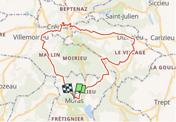
Trail Walking of 19 km to be discovered at Auvergne-Rhône-Alpes, Isère, Moras. This trail is proposed by fernand1254.

Description

Belle rando, avec des paysages variés. Il faut d'une manière générale en partant du parking de l'église de Moras, suivre le balisage jaunes (panneaux départementaux).
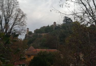
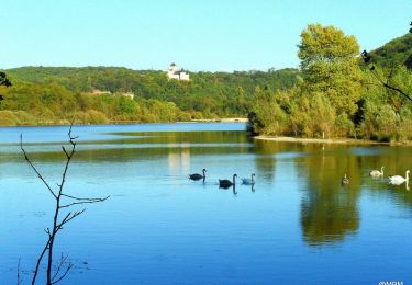
A Crémieu, il faut voir le cloître, l'église(très beaux vitraux). Les halles, monter jusqu'aux chateaux.
C'est une commune où il fait bon vivre.

Elevation profile

Positioning

Country:
France
Region :
Auvergne-Rhône-Alpes
Department/Province :
Isère
Municipality :
Moras
Location:
Unknown
Start:(UTM)
675779 ; 5061920 (31T) N.

Trails nearby

Trail Walking Moras - Balade autour de Crizieu - Moras - Photo
Walking
tracegps

Walking

Easy
(2)
Moras, Auvergne-Rhône-Alpes, Isère, France
5.5 km | 7.2 km-effort
1h 30min
Yes
Trail Mountain bike Veyssilieu - Le Dauphin de l'Isle d'Abeau 2008 - 35 kms - Photo
Mountain bike
tracegps

Mountain bike

Difficult
(2)
Veyssilieu, Auvergne-Rhône-Alpes, Isère, France
34 km | 43 km-effort
2h 30min
Yes
Trail Walking Siccieu-Saint-Julien-et-Carisieu - Etang-de-Ry Siccieu 10km 245m - Photo
Walking
pzvictor

Walking

Easy
(1)
Siccieu-Saint-Julien-et-Carisieu, Auvergne-Rhône-Alpes, Isère, France
9.8 km | 13.1 km-effort
3h 0min
Yes
Trail On foot Moras - etang de moras - Photo
On foot
Christophe Ontavilla

On foot

Easy
Moras, Auvergne-Rhône-Alpes, Isère, France
9 km | 11.8 km-effort
Unknown
Yes
Trail Mountain bike Crémieu - Voie verte Crémieu Arandon - Photo
Mountain bike
SyMA

Mountain bike

Very easy
Crémieu, Auvergne-Rhône-Alpes, Isère, France
41 km | 45 km-effort
3h 11min
Yes
Trail Mountain bike Crémieu - Le mémorial des aviateurs - Crémieu - Photo
Mountain bike
tracegps

Mountain bike

Difficult
Crémieu, Auvergne-Rhône-Alpes, Isère, France
29 km | 37 km-effort
2h 30min
Yes
Trail Walking Crémieu - Le mémorial des aviateurs - Crémieu - Photo
Walking
tracegps

Walking

Difficult
(1)
Crémieu, Auvergne-Rhône-Alpes, Isère, France
29 km | 37 km-effort
5h 30min
Yes
Trail Walking Chozeau - muguet reconnu le 250419 - Photo
Walking
lydiaodile

Walking

Very easy
Chozeau, Auvergne-Rhône-Alpes, Isère, France
4 km | 5.7 km-effort
1h 36min
Yes
Trail sport Villemoirieu - Villeroi - Photo
sport
pzvictor

sport

Very easy
Villemoirieu, Auvergne-Rhône-Alpes, Isère, France
9.7 km | 13.2 km-effort
Unknown
Yes


Close
My subscriptions