Trail Walking Sainte-Tulle - 1Chabrands, le CLAPIER, LE cAIRN - Photo
 liocol
liocol

User

© OpenStreetMap contributors
Length
Length
7.8 km
Max alt
Max alt
455 m
Uphill gradient
Uphill gradient
293 m
Km-Effort
Km-Effort  
11.7 km
Min alt
Min alt
308 m
Downhill gradient
Downhill gradient
295 m
Boucle
Boucle
Yes
Creation date :
2021-11-22 08:19:29.959
Updated on :
2023-10-14 15:44:07.574

(0 Reviews)

Walking
Walking
2h15
Difficulty : Medium

Scan this QR Code to open this trail in the SityTrail application

FREE GPS app for hiking

Logo SityTrail SityTrail

IGN / Geographical institutes

Download SityTrail from the App Store Download SityTrail from Google Play

Logo SityTrail SityTrail World

The world is yours!

Download SityTrail from the App Store Download SityTrail from Google Play Download SityTrail on Huawei AppGallery

About

Trail Walking of 7.8 km to be discovered at Provence-Alpes-Côte d'Azur, Alpes-de-Haute-Provence, Sainte-Tulle. This trail is proposed by liocol.

Description

Garez vous le long d'un chemin, sur la C4, entre le chemin de Ste Tulle et la rue de Montfuron.
Boucle qui passe par le trou du Loup et le Cairn.

Elevation profile

Photos

Positioning

Country:
France
Region :
Provence-Alpes-Côte d'Azur
Department/Province :
Alpes-de-Haute-Provence
Municipality :
Sainte-Tulle
Location:
Unknown
Start:(UTM)
721009 ; 4852518 (31T) N.

Trails nearby

Trail Walking Corbières-en-Provence - 06-06-2023 Trou du loup - Photo
Walking
GUIDE
Kargil

Walking

Difficult
Corbières-en-Provence, Provence-Alpes-Côte d'Azur, Alpes-de-Haute-Provence, France
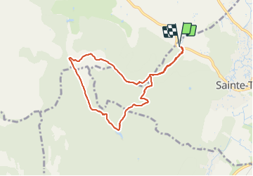
12.1 km | 16.3 km-effort
3h 42min
Yes
Trail Walking Montfuron - 1Montfuron, Villemus via la Colle et le Moulin. - Photo
Walking
liocol

Walking

Easy
Montfuron, Provence-Alpes-Côte d'Azur, Alpes-de-Haute-Provence, France
7.6 km | 9.9 km-effort
2h 4min
Yes
Trail Walking Montfuron - 1Montfuron, le relais de Villemus - Photo
Walking
liocol

Walking

Medium
Montfuron, Provence-Alpes-Côte d'Azur, Alpes-de-Haute-Provence, France
8 km | 11.2 km-effort
2h 9min
Yes
Trail Walking Montfuron - Montfuron à Villemus, variante.  - Photo
Walking
liocol

Walking

Easy
(2)
Montfuron, Provence-Alpes-Côte d'Azur, Alpes-de-Haute-Provence, France
7.6 km | 9.8 km-effort
2h 3min
Yes
Trail Walking Manosque - 1Le grand Tour de Toutes Aures - Photo
Walking
liocol

Walking

Easy
Manosque, Provence-Alpes-Côte d'Azur, Alpes-de-Haute-Provence, France
8.8 km | 11.1 km-effort
2h 22min
No
Trail Walking Pierrevert - 2Pierrevert, la petite gardette - Photo
Walking
liocol

Walking

Easy
Pierrevert, Provence-Alpes-Côte d'Azur, Alpes-de-Haute-Provence, France
8.1 km | 10.3 km-effort
2h 17min
Yes
Trail Walking Corbières-en-Provence - 1Corbières, chemin de repentance et trou du Loup - Photo
Walking
liocol

Walking

Medium
Corbières-en-Provence, Provence-Alpes-Côte d'Azur, Alpes-de-Haute-Provence, France
8.9 km | 12.6 km-effort
2h 35min
Yes
Trail Walking Montfuron - 1Montfuron, via les Granges et le chemin Mériton - Photo
Walking
liocol

Walking

Difficult
Montfuron, Provence-Alpes-Côte d'Azur, Alpes-de-Haute-Provence, France
9.5 km | 13.9 km-effort
2h 36min
Yes
Trail Walking Montfuron - Montfuron, départ P entrée village - Photo
Walking
liocol

Walking

Easy
Montfuron, Provence-Alpes-Côte d'Azur, Alpes-de-Haute-Provence, France
4.7 km | 6.4 km-effort
1h 57min
Yes


Close
My subscriptions