


D2 - GR 10

loic09
User
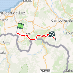

Length
23 km

Max alt
557 m

Uphill gradient
831 m
Km-Effort
34 km

Min alt
47 m

Downhill gradient
806 m
Boucle
No
Creation date :
2014-12-10 00:00:00.0
Updated on :
2014-12-10 00:00:00.0
7h01
Difficulty : Medium

FREE GPS app for hiking
 SityTrail
IGN / Geographical institutes
SityTrail Plus
The world is yours!
About
Trail Walking of 23 km to be discovered at New Aquitaine, Pyrénées-Atlantiques, Ascain. This trail is proposed by loic09.
Description
Du Col des Trois Fontaines au Col de Zuharretako

Positioning
Country:
France
Region :
New Aquitaine
Department/Province :
Pyrénées-Atlantiques
Municipality :
Ascain
Location:
Unknown
Start:(Dec)
Start:(UTM)
611272 ; 4796968 (30T) N.
Comments