


St Martin Chateau-Peyrat le chateau AR

christian19
User
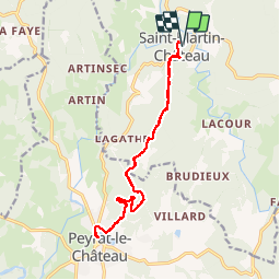

Length
17.3 km

Max alt
624 m

Uphill gradient
446 m
Km-Effort
23 km

Min alt
426 m

Downhill gradient
447 m
Boucle
Yes
Creation date :
2014-12-10 00:00:00.0
Updated on :
2014-12-10 00:00:00.0
3h52
Difficulty : Easy

FREE GPS app for hiking
 SityTrail
IGN / Geographical institutes
SityTrail Plus
The world is yours!
About
Trail Walking of 17.3 km to be discovered at New Aquitaine, Creuse, Saint-Martin-Château. This trail is proposed by christian19.
Description
La voie de Rocamadour
Positioning
Country:
France
Region :
New Aquitaine
Department/Province :
Creuse
Municipality :
Saint-Martin-Château
Location:
Unknown
Start:(Dec)
Start:(UTM)
406847 ; 5078950 (31T) N.
Comments