


D9 - GR 10

loic09
User
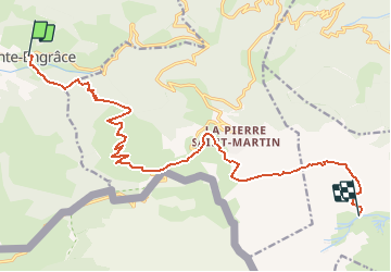

Length
17.6 km

Max alt
1957 m

Uphill gradient
1603 m
Km-Effort
35 km

Min alt
585 m

Downhill gradient
548 m
Boucle
No
Creation date :
2014-12-10 00:00:00.0
Updated on :
2014-12-10 00:00:00.0
7h41
Difficulty : Medium

FREE GPS app for hiking
 SityTrail
IGN / Geographical institutes
SityTrail Plus
The world is yours!
About
Trail Walking of 17.6 km to be discovered at New Aquitaine, Pyrénées-Atlantiques, Sainte-Engrâce. This trail is proposed by loic09.
Description
St Engrace/Cap de la Baitch
Positioning
Country:
France
Region :
New Aquitaine
Department/Province :
Pyrénées-Atlantiques
Municipality :
Sainte-Engrâce
Location:
Unknown
Start:(Dec)
Start:(UTM)
678530 ; 4762668 (30T) N.
Comments