


wettolsheim chapelle_des_bois

jcschubnel
User
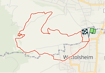

Length
6.2 km

Max alt
392 m

Uphill gradient
189 m
Km-Effort
8.8 km

Min alt
210 m

Downhill gradient
189 m
Boucle
Yes
Creation date :
2021-11-29 12:11:27.944
Updated on :
2021-11-29 20:19:07.173
2h30
Difficulty : Medium

FREE GPS app for hiking
 SityTrail
IGN / Geographical institutes
SityTrail Plus
The world is yours!
About
Trail Walking of 6.2 km to be discovered at Grand Est, Haut-Rhin, Wettolsheim. This trail is proposed by jcschubnel.
Positioning
Country:
France
Region :
Grand Est
Department/Province :
Haut-Rhin
Municipality :
Wettolsheim
Location:
Unknown
Start:(Dec)
Start:(UTM)
373617 ; 5324561 (32U) N.
Comments