


D6 - GR 10

loic09
User
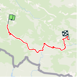

Length
22 km

Max alt
1420 m

Uphill gradient
1421 m
Km-Effort
40 km

Min alt
671 m

Downhill gradient
1058 m
Boucle
No
Creation date :
2014-12-10 00:00:00.0
Updated on :
2014-12-10 00:00:00.0
8h24
Difficulty : Medium

FREE GPS app for hiking
 SityTrail
IGN / Geographical institutes
SityTrail Plus
The world is yours!
About
Trail Walking of 22 km to be discovered at New Aquitaine, Pyrénées-Atlantiques, Estérençuby. This trail is proposed by loic09.
Description
Col d'Hitturamburu/Crètes Ugatzé

Positioning
Country:
France
Region :
New Aquitaine
Department/Province :
Pyrénées-Atlantiques
Municipality :
Estérençuby
Location:
Unknown
Start:(Dec)
Start:(UTM)
650098 ; 4771281 (30T) N.
Comments