


Pont de Reynes Vallera

Phidel66
User
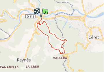

Length
6.9 km

Max alt
304 m

Uphill gradient
183 m
Km-Effort
9.4 km

Min alt
161 m

Downhill gradient
184 m
Boucle
Yes
Creation date :
2021-11-30 12:25:50.632
Updated on :
2024-05-29 13:37:53.834
2h07
Difficulty : Medium

FREE GPS app for hiking
 SityTrail
IGN / Geographical institutes
SityTrail Plus
The world is yours!
About
Trail Walking of 6.9 km to be discovered at Occitania, Pyrénées-Orientales, Reynès. This trail is proposed by Phidel66.
Description
Romarins
Positioning
Country:
France
Region :
Occitania
Department/Province :
Pyrénées-Orientales
Municipality :
Reynès
Location:
Unknown
Start:(Dec)
Start:(UTM)
476790 ; 4704695 (31T) N.
Comments