Trail Walking Ossey-les-Trois-Maisons - entre Ossey et Marigny - Photo

entre Ossey et Marigny

© OpenStreetMap contributors
Length
Length
12.2 km
Max alt
Max alt
178 m
Uphill gradient
Uphill gradient
109 m
Km-Effort
Km-Effort  
13.7 km
Min alt
Min alt
104 m
Downhill gradient
Downhill gradient
109 m
Boucle
Boucle
Yes
Creation date :
2021-12-02 08:34:47.34
Updated on :
2021-12-02 16:22:15.907

(0 Reviews)

Walking
Walking
2h47
Difficulty : Easy

Scan this QR Code to open this trail in the SityTrail application

FREE GPS app for hiking

Logo SityTrail SityTrail

IGN / Geographical institutes

Download SityTrail from the App Store Download SityTrail from Google Play

Logo SityTrail SityTrail World

The world is yours!

Download SityTrail from the App Store Download SityTrail from Google Play Download SityTrail on Huawei AppGallery

About

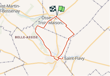
Trail Walking of 12.2 km to be discovered at Grand Est, Aube, Ossey-les-Trois-Maisons. This trail is proposed by jeannine grandjean.

Description

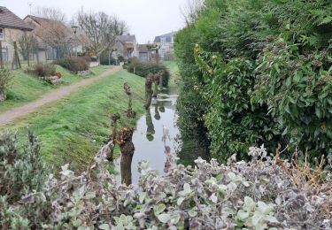
entre les deux villages, le long de l'Ardusson
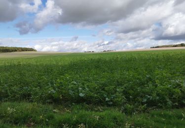
retour par le petit bois de la Potence puis à travers champs

Elevation profile

Positioning

Country:
France
Region :
Grand Est
Department/Province :
Aube
Municipality :
Ossey-les-Trois-Maisons
Location:
Unknown
Start:(UTM)
554500 ; 5364890 (31U) N.

Trails nearby

Trail Walking Marigny-le-Châtel - au fil de l'eau, de MARIGNY le CHATEL à SAINT FLAVY - Photo
Walking
jeannine grandjean

Walking

Difficult
Marigny-le-Châtel, Grand Est, Aube, France
13 km | 14.9 km-effort
3h 19min
Yes
Trail Walking Marigny-le-Châtel - Boucle de St Flavy -  Marigny-le-Châtel  - Photo
Walking
tracegps

Walking

Easy
Marigny-le-Châtel, Grand Est, Aube, France
4.3 km | 4.6 km-effort
1h 4min
Yes
Trail Walking Marigny-le-Châtel - Marigny la chatel - Photo
Walking
Arnaud de Charrin

Walking

Easy
Marigny-le-Châtel, Grand Est, Aube, France
11.1 km | 12 km-effort
2h 20min
Yes
Trail Walking Marigny-le-Châtel - boucle de Marigny - Photo
Walking
danpar

Walking

Very difficult
Marigny-le-Châtel, Grand Est, Aube, France
20 km | 22 km-effort
5h 3min
Yes
Trail Walking Origny-le-Sec - Boucle Origny le Sec, les Rouillons  - Photo
Walking
NANE51

Walking

Easy
(1)
Origny-le-Sec, Grand Est, Aube, France
10.7 km | 11.6 km-effort
2h 37min
Yes
Trail Walking Marigny-le-Châtel - Marigny/Deshy 12.9 km d=89 m - Photo
Walking
Alain Picard

Walking

Difficult
Marigny-le-Châtel, Grand Est, Aube, France
13 km | 14.1 km-effort
3h 11min
Yes
Trail Walking Marigny-le-Châtel - Marigny/Deshy 12.9 km d=89 m - Photo
Walking
Alain Picard

Walking

Difficult
Marigny-le-Châtel, Grand Est, Aube, France
13 km | 14.1 km-effort
3h 11min
Yes
Trail Mountain bike Origny-le-Sec - origny 280721 - Photo
Mountain bike
joeljoseph

Mountain bike

Very difficult
Origny-le-Sec, Grand Est, Aube, France
43 km | 46 km-effort
2h 31min
Yes
Trail On foot Saint-Martin-de-Bossenay - St-Martin-de-Bossenay - Photo
On foot
Alain Picard

On foot

Easy
Saint-Martin-de-Bossenay, Grand Est, Aube, France
11.3 km | 12.8 km-effort
Unknown
Yes


Close
My subscriptions