Trail Walking Marigny-le-Châtel - au fil de l'eau, de MARIGNY le CHATEL à SAINT FLAVY - Photo

au fil de l'eau, de MARIGNY le CHATEL à SAINT FLAVY

© OpenStreetMap contributors
Length
Length
13 km
Max alt
Max alt
180 m
Uphill gradient
Uphill gradient
140 m
Km-Effort
Km-Effort  
14.9 km
Min alt
Min alt
105 m
Downhill gradient
Downhill gradient
140 m
Boucle
Boucle
Yes
Creation date :
2022-03-15 15:15:10.723
Updated on :
2022-03-17 14:42:32.799

(0 Reviews)

Walking
Walking
3h19
Difficulty : Difficult

Scan this QR Code to open this trail in the SityTrail application

FREE GPS app for hiking

Logo SityTrail SityTrail

IGN / Geographical institutes

Download SityTrail from the App Store Download SityTrail from Google Play

Logo SityTrail SityTrail World

The world is yours!

Download SityTrail from the App Store Download SityTrail from Google Play Download SityTrail on Huawei AppGallery

About

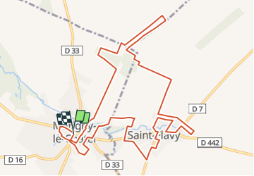
Trail Walking of 13 km to be discovered at Grand Est, Aube, Marigny-le-Châtel. This trail is proposed by jeannine grandjean.

Description

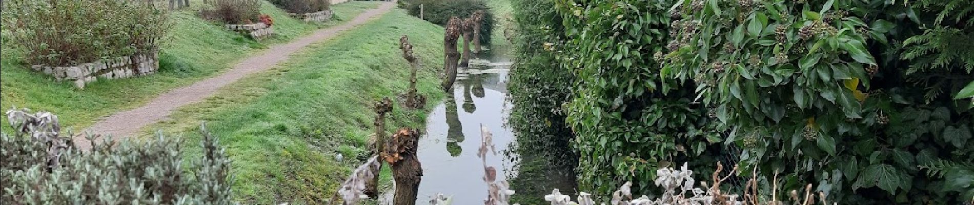
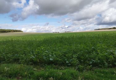
Agréable randonnée sur des sentiers à travers champs, suivant l'orée du bois ou longeant le ruisseau de l'Ardusson jusqu'à sa source à Saint Flavy.
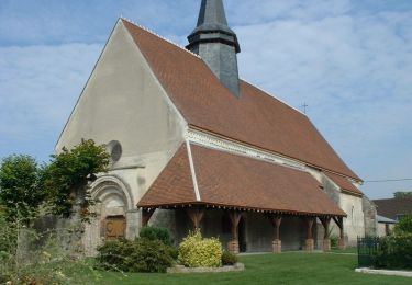
Belles promenades le long des rives  de l'Ardusson à Marigny,  Ne pas manquer le lavoir de la source, à Saint Flavy, ni la superbe église du 12ème siècle.

Elevation profile

Photos

Positioning

Country:
France
Region :
Grand Est
Department/Province :
Aube
Municipality :
Marigny-le-Châtel
Location:
Unknown
Start:(UTM)
554512 ; 5361365 (31U) N.

Trails nearby

Trail Walking Marigny-le-Châtel - Boucle de St Flavy -  Marigny-le-Châtel  - Photo
Walking
tracegps

Walking

Easy
Marigny-le-Châtel, Grand Est, Aube, France
4.3 km | 4.6 km-effort
1h 4min
Yes
Trail Walking Marigny-le-Châtel - Marigny la chatel - Photo
Walking
Arnaud de Charrin

Walking

Easy
Marigny-le-Châtel, Grand Est, Aube, France
11.1 km | 12 km-effort
2h 20min
Yes
Trail Walking Marigny-le-Châtel - boucle de Marigny - Photo
Walking
danpar

Walking

Very difficult
Marigny-le-Châtel, Grand Est, Aube, France
20 km | 22 km-effort
5h 3min
Yes
Trail Walking Prunay-Belleville - Boucle Prunay - Photo
Walking
NANE51

Walking

Difficult
Prunay-Belleville, Grand Est, Aube, France
14 km | 15 km-effort
2h 59min
No
Trail Walking Ossey-les-Trois-Maisons - entre Ossey et Marigny - Photo
Walking
jeannine grandjean

Walking

Easy
Ossey-les-Trois-Maisons, Grand Est, Aube, France
12.2 km | 13.7 km-effort
2h 47min
Yes
Trail Walking Marigny-le-Châtel - Marigny/Deshy 12.9 km d=89 m - Photo
Walking
Alain Picard

Walking

Difficult
Marigny-le-Châtel, Grand Est, Aube, France
13 km | 14.1 km-effort
3h 11min
Yes
Trail Walking Marigny-le-Châtel - Marigny/Deshy 12.9 km d=89 m - Photo
Walking
Alain Picard

Walking

Difficult
Marigny-le-Châtel, Grand Est, Aube, France
13 km | 14.1 km-effort
3h 11min
Yes
Trail On foot Prunay-Belleville - Prunay-Belleville - Photo
On foot
Alain Picard

On foot

Easy
Prunay-Belleville, Grand Est, Aube, France
12.9 km | 13.9 km-effort
3h 8min
Yes
Trail On foot Saint-Martin-de-Bossenay - St-Martin-de-Bossenay - Photo
On foot
Alain Picard

On foot

Easy
Saint-Martin-de-Bossenay, Grand Est, Aube, France
11.3 km | 12.8 km-effort
Unknown
Yes


Close
My subscriptions