


Les sarcophages

houbart
User
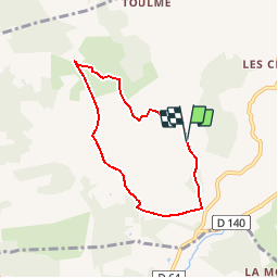

Length
6 km

Max alt
244 m

Uphill gradient
142 m
Km-Effort
7.9 km

Min alt
157 m

Downhill gradient
144 m
Boucle
Yes
Creation date :
2014-12-10 00:00:00.0
Updated on :
2019-10-25 15:07:13.686
1h42
Difficulty : Easy

FREE GPS app for hiking
 SityTrail
IGN / Geographical institutes
SityTrail Plus
The world is yours!
About
Trail Walking of 6 km to be discovered at New Aquitaine, Corrèze, Louignac. This trail is proposed by houbart.
Description
Départ sur la D51 en direction de Toulme, entre Villac et Louignac.
Positioning
Country:
France
Region :
New Aquitaine
Department/Province :
Corrèze
Municipality :
Louignac
Location:
Unknown
Start:(Dec)
Start:(UTM)
363692 ; 5007809 (31T) N.
Comments