


Croix magne

PascalBanide
User
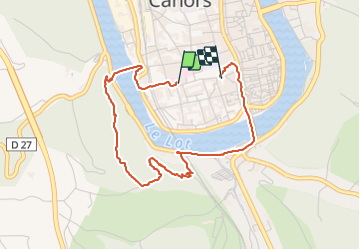

Length
4.1 km

Max alt
240 m

Uphill gradient
145 m
Km-Effort
6 km

Min alt
110 m

Downhill gradient
144 m
Boucle
No
Creation date :
2021-12-12 13:18:08.0
Updated on :
2021-12-12 14:57:50.287
1h39
Difficulty : Easy

FREE GPS app for hiking
 SityTrail
IGN / Geographical institutes
SityTrail Plus
The world is yours!
About
Trail Walking of 4.1 km to be discovered at Occitania, Lot, Cahors. This trail is proposed by PascalBanide.
Positioning
Country:
France
Region :
Occitania
Department/Province :
Lot
Municipality :
Cahors
Location:
Unknown
Start:(Dec)
Start:(UTM)
375576 ; 4922409 (31T) N.
Comments