


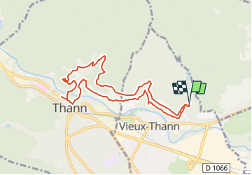
Parking Chemin du Zuhren - Croix de Rangen - Oeil de la Sorcière - Caséus - Chapelle Urban - Drarenfels et retour

patrickbeyrath
User

Length
9 km

Max alt
502 m

Uphill gradient
312 m
Km-Effort
13.2 km

Min alt
333 m

Downhill gradient
310 m
Boucle
Yes
Creation date :
2021-12-15 17:12:27.675
Updated on :
2021-12-17 08:23:59.273
2h41
Difficulty : Medium

FREE GPS app for hiking
 SityTrail
IGN / Geographical institutes
SityTrail Plus
The world is yours!
About
Trail Walking of 9 km to be discovered at Grand Est, Haut-Rhin, Vieux-Thann. This trail is proposed by patrickbeyrath.
Positioning
Country:
France
Region :
Grand Est
Department/Province :
Haut-Rhin
Municipality :
Vieux-Thann
Location:
Unknown
Start:(Dec)
Start:(UTM)
360110 ; 5296963 (32T) N.
Comments