Trail Walking Saint-Hilaire-la-Gravelle - Saint-Hilaire-la-Gravelle - Entre Loir et étangs  - Photo

Saint-Hilaire-la-Gravelle - Entre Loir et étangs

 guydu41
guydu41

User

© OpenStreetMap contributors
Length
Length
16.5 km
Max alt
Max alt
153 m
Uphill gradient
Uphill gradient
184 m
Km-Effort
Km-Effort  
18.9 km
Min alt
Min alt
85 m
Downhill gradient
Downhill gradient
185 m
Boucle
Boucle
Yes
Creation date :
2021-12-17 08:16:32.906
Updated on :
2021-12-18 06:59:53.367

(0 Reviews)

Walking
Walking
4h44
Difficulty : Easy

Scan this QR Code to open this trail in the SityTrail application

FREE GPS app for hiking

Logo SityTrail SityTrail

IGN / Geographical institutes

Download SityTrail from the App Store Download SityTrail from Google Play

Logo SityTrail SityTrail World

The world is yours!

Download SityTrail from the App Store Download SityTrail from Google Play Download SityTrail on Huawei AppGallery

About

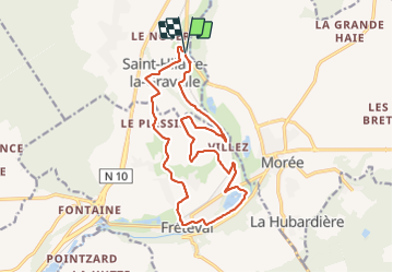
Trail Walking of 16.5 km to be discovered at Centre-Loire Valley, Loir-et-Cher, Saint-Hilaire-la-Gravelle. This trail is proposed by guydu41.

Description

Randonnée de 16 km dans le sens horaire depuis le parking devant la Mairie de Saint-Hilaire-la-Gravelle, 10 rue Léon Cibie.
Ce circuit balisé jaune "Entre Loir et étangs" emprunte un très beau chemin en lisière d'un coteau boisé, le long d'une petite ligne de chemin de fer, traverse plusieurs champs, contourne l'étang de Saint-Lubin et ses aires de pique-nique, permet d'apprécier plusieurs points de vue sur la vallée du Loir.

Elevation profile

Photos

Positioning

Country:
France
Region :
Centre-Loire Valley
Department/Province :
Loir-et-Cher
Municipality :
Saint-Hilaire-la-Gravelle
Location:
Unknown
Start:(UTM)
366079 ; 5309477 (31T) N.

Trails nearby

Trail Walking Fréteval - Fréteval - Photo
Walking
guydu41

Walking

Medium
Fréteval, Centre-Loire Valley, Loir-et-Cher, France
10.8 km | 12.5 km-effort
2h 50min
Yes
Trail Walking Fréteval - Fréteval - L'histoire en chemin - Photo
Walking
guydu41

Walking

Easy
Fréteval, Centre-Loire Valley, Loir-et-Cher, France
19.7 km | 22 km-effort
6h 25min
Yes
Trail Cycle Fréteval - Circuit des 2 coteaux - Fréteval - Photo
Cycle
tracegps

Cycle

Difficult
Fréteval, Centre-Loire Valley, Loir-et-Cher, France
48 km | 54 km-effort
3h 0min
Yes
Trail Mountain bike Morée - Circuit de vallées et coteaux n° 3 - Morée - Photo
Mountain bike
tracegps

Mountain bike

Medium
Morée, Centre-Loire Valley, Loir-et-Cher, France
16.5 km | 18.9 km-effort
2h 0min
Yes
Trail Walking Fréteval - freteval 12 kms - Photo
Walking
migauthi

Walking

Very easy
Fréteval, Centre-Loire Valley, Loir-et-Cher, France
12.3 km | 14.1 km-effort
2h 44min
Yes
Trail Walking Fréteval - Freteval 27022022 - Photo
Walking
laurence41

Walking

Very difficult
Fréteval, Centre-Loire Valley, Loir-et-Cher, France
27 km | 30 km-effort
5h 20min
Yes
Trail On foot Fréteval - Randonnée Fréteval-Morée - Photo
On foot
Jean LABADIE

On foot

Medium
Fréteval, Centre-Loire Valley, Loir-et-Cher, France
19.5 km | 22 km-effort
5h 1min
Yes
Trail Walking Fréteval - freteval david - Photo
Walking
richardlelot

Walking

Very easy
Fréteval, Centre-Loire Valley, Loir-et-Cher, France
14.2 km | 16.8 km-effort
2h 15min
Yes
Trail Motor Morée - rendo bruno - Photo
Motor
ludo41

Motor

Medium
Morée, Centre-Loire Valley, Loir-et-Cher, France
66 km | 73 km-effort
3h 48min
Yes


Close
My subscriptions