


ayherre

jcm17
User
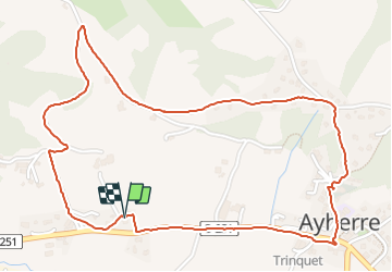

Length
3.2 km

Max alt
144 m

Uphill gradient
98 m
Km-Effort
4.6 km

Min alt
54 m

Downhill gradient
98 m
Boucle
Yes
Creation date :
2021-12-23 15:59:12.751
Updated on :
2021-12-23 16:59:02.0
59m
Difficulty : Easy

FREE GPS app for hiking
 SityTrail
IGN / Geographical institutes
SityTrail Plus
The world is yours!
About
Trail Walking of 3.2 km to be discovered at New Aquitaine, Pyrénées-Atlantiques, Ayherre. This trail is proposed by jcm17.
Positioning
Country:
France
Region :
New Aquitaine
Department/Province :
Pyrénées-Atlantiques
Municipality :
Ayherre
Location:
Unknown
Start:(Dec)
Start:(UTM)
640738 ; 4805868 (30T) N.
Comments