


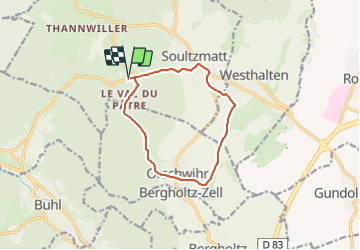
Cimetière Roumain Soultzmatt-Château du Wagenbourg-Chapelle du Bollenberg-Caveau d'Orschwihr-Château du Stettenberg-Le Val du Pâtre et retour

patrickbeyrath
User

Length
10.4 km

Max alt
418 m

Uphill gradient
290 m
Km-Effort
14.2 km

Min alt
239 m

Downhill gradient
289 m
Boucle
Yes
Creation date :
2021-12-31 07:58:41.153
Updated on :
2021-12-31 08:01:14.554
3h13
Difficulty : Medium

FREE GPS app for hiking
 SityTrail
IGN / Geographical institutes
SityTrail Plus
The world is yours!
About
Trail Walking of 10.4 km to be discovered at Grand Est, Haut-Rhin, Soultzmatt. This trail is proposed by patrickbeyrath.
Positioning
Country:
France
Region :
Grand Est
Department/Province :
Haut-Rhin
Municipality :
Soultzmatt
Location:
Unknown
Start:(Dec)
Start:(UTM)
366849 ; 5313026 (32T) N.
Comments