Trail Walking Labatie-d'Andaure - Le rocher de Peyrolle Labatie d Andaure - Photo

Le rocher de Peyrolle Labatie d Andaure

© OpenStreetMap contributors
Length
Length
7.4 km
Max alt
Max alt
881 m
Uphill gradient
Uphill gradient
355 m
Km-Effort
Km-Effort  
12.1 km
Min alt
Min alt
522 m
Downhill gradient
Downhill gradient
355 m
Boucle
Boucle
Yes
Creation date :
2022-01-02 12:43:02.682
Updated on :
2022-01-02 15:04:38.615

(1 Reviews)

Walking
Walking
2h01
Difficulty : Difficult

Scan this QR Code to open this trail in the SityTrail application

FREE GPS app for hiking

Logo SityTrail SityTrail

IGN / Geographical institutes

Download SityTrail from the App Store Download SityTrail from Google Play

Logo SityTrail SityTrail World

The world is yours!

Download SityTrail from the App Store Download SityTrail from Google Play Download SityTrail on Huawei AppGallery

About

Trail Walking of 7.4 km to be discovered at Auvergne-Rhône-Alpes, Ardèche, Labatie-d'Andaure. This trail is proposed by brigitte07.

Elevation profile

Photos

Positioning

Country:
France
Region :
Auvergne-Rhône-Alpes
Department/Province :
Ardèche
Municipality :
Labatie-d'Andaure
Location:
Unknown
Start:(UTM)
617557 ; 4986763 (31T) N.

Comments

Please log in to post a review or rate the element


Trails nearby

Trail Walking Saint-Jeure-d'Andaure - En pays d'Andaure - Photo
Walking
tracegps

Walking

Medium
(1)
Saint-Jeure-d'Andaure, Auvergne-Rhône-Alpes, Ardèche, France
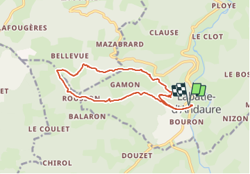
6.8 km | 10.1 km-effort
2h 30min
Yes
Trail Walking Saint-Agrève - La chaux par les Sagnoles - Photo
Walking
mallovon

Walking

Medium
(1)
Saint-Agrève, Auvergne-Rhône-Alpes, Ardèche, France
6.4 km | 8.9 km-effort
2h 17min
Yes
Trail Walking Saint-Agrève - Le serre par le col de brun - Photo
Walking
mallovon

Walking

Easy
Saint-Agrève, Auvergne-Rhône-Alpes, Ardèche, France
4.1 km | 5.1 km-effort
1h 20min
Yes
Trail Walking Nozières - Col du Buisson - Nozières - Photo
Walking
tracegps

Walking

Medium
Nozières, Auvergne-Rhône-Alpes, Ardèche, France
12 km | 18 km-effort
3h 30min
Yes
Trail Mountain bike Désaignes - Autour de Combeneyre - Désaignes - Photo
Mountain bike
tracegps

Mountain bike

Medium
Désaignes, Auvergne-Rhône-Alpes, Ardèche, France
13.1 km | 18.3 km-effort
1h 30min
Yes
Trail Walking Désaignes - Autour de Combeneyre - Désaignes - Photo
Walking
tracegps

Walking

Medium
Désaignes, Auvergne-Rhône-Alpes, Ardèche, France
13.1 km | 18.3 km-effort
3h 0min
Yes
Trail Walking Désaignes - Autour de Sialle - Désaignes - Photo
Walking
tracegps

Walking

Difficult
Désaignes, Auvergne-Rhône-Alpes, Ardèche, France
8.4 km | 13.5 km-effort
3h 30min
Yes
Trail Walking Désaignes - La Terrasse - Désaignes - Photo
Walking
tracegps

Walking

Medium
Désaignes, Auvergne-Rhône-Alpes, Ardèche, France
13.3 km | 21 km-effort
4h 0min
Yes
Trail Walking Désaignes - Les Sauvages - Desaignes - Photo
Walking
tracegps

Walking

Medium
Désaignes, Auvergne-Rhône-Alpes, Ardèche, France
12.3 km | 17.1 km-effort
3h 0min
Yes


Close
My subscriptions