Trail Walking Montfrin - Montfrin   chapelle St Amand - Photo

Montfrin chapelle St Amand

 Manoune
Manoune

User

© OpenStreetMap contributors
Length
Length
16.7 km
Max alt
Max alt
68 m
Uphill gradient
Uphill gradient
198 m
Km-Effort
Km-Effort  
19.3 km
Min alt
Min alt
10 m
Downhill gradient
Downhill gradient
199 m
Boucle
Boucle
Yes
Creation date :
2022-01-03 07:51:44.429
Updated on :
2022-01-04 09:29:26.97

(0 Reviews)

Walking
Walking
5h12
Difficulty : Medium

Scan this QR Code to open this trail in the SityTrail application

FREE GPS app for hiking

Logo SityTrail SityTrail

IGN / Geographical institutes

Download SityTrail from the App Store Download SityTrail from Google Play

Logo SityTrail SityTrail World

The world is yours!

Download SityTrail from the App Store Download SityTrail from Google Play Download SityTrail on Huawei AppGallery

About

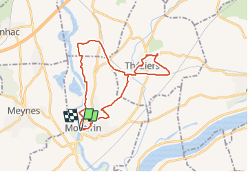
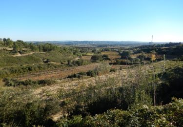
Trail Walking of 16.7 km to be discovered at Occitania, Gard, Montfrin. This trail is proposed by Manoune.

Description

Parking tennis ,place de la liberté
Passer vers le vers Château , chemin  du site de la Baume  et ruchers de Montagnac, Massay, chemin de fer, la suivre jusqu'au Mas de Guiraud, prendre à gauche , faire un tour à la Chapelle St Amand, se diriger vers Théziers traversée le village avec une petite visite, Palisse, Mas de Langlade se trouve de l'autre côté de la ligne SNCF, le Pradas, le Fray, Mas Syndic, les arènes, parking. ( bonne randonnée).

Elevation profile

Photos

Positioning

Country:
France
Region :
Occitania
Department/Province :
Gard
Municipality :
Montfrin
Location:
Unknown
Start:(UTM)
627792 ; 4859278 (31T) N.

Trails nearby

Trail Walking Comps - Abbaye de St-Roman - Photo
Walking
Amaralain

Walking

Easy
(1)
Comps, Occitania, Gard, France
5 km | 6.8 km-effort
1h 27min
Yes
Trail Walking Sernhac - Sernhac - tunnels Court - Photo
Walking
rando30129

Walking

Medium
(1)
Sernhac, Occitania, Gard, France
5.8 km | 7.1 km-effort
1h 26min
Yes
Trail Walking Sernhac - Sernhac aqueduc tunnels Pont  - Photo
Walking
kephas

Walking

Medium
Sernhac, Occitania, Gard, France
14 km | 18.9 km-effort
6h 16min
Yes
Trail Walking Théziers - Trace rando Théziers - Fosses de Fournès - Photo
Walking
Maryma

Walking

Medium
(1)
Théziers, Occitania, Gard, France
16.6 km | 22 km-effort
4h 54min
Yes
Trail Walking Théziers - THEZIERS  Le Castellas - Photo
Walking
Manoune

Walking

Medium
Théziers, Occitania, Gard, France
19.8 km | 24 km-effort
6h 0min
Yes
Trail Walking Sernhac - Sernhac les tunnels  - Photo
Walking
Manoune

Walking

Medium
Sernhac, Occitania, Gard, France
12.3 km | 16.5 km-effort
4h 30min
Yes
Trail Hybrid bike Comps - Voie verte depuis barrage de Vallabrègues Intersport Marguillier Saint Félix et fin au château de Beaucaire  - Photo
Hybrid bike
jacqk

Hybrid bike

Easy
Comps, Occitania, Gard, France
9.1 km | 10.4 km-effort
1h 0min
No
Trail Walking Sernhac - Les tunnels de Sernahc  le pont du Gard - Photo
Walking
daniel34

Walking

Difficult
(1)
Sernhac, Occitania, Gard, France
14.7 km | 20 km-effort
4h 56min
Yes
Trail Mountain bike Théziers - Domazan et le Castelas - Théziers - Photo
Mountain bike
tracegps

Mountain bike

Difficult
Théziers, Occitania, Gard, France
18.2 km | 23 km-effort
3h 30min
Yes


Close
My subscriptions