


Le Haut de Cères Coll de Bossell

Phidel66
User
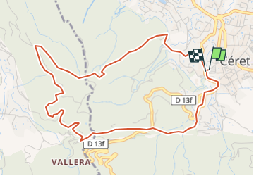

Length
6 km

Max alt
306 m

Uphill gradient
220 m
Km-Effort
9 km

Min alt
166 m

Downhill gradient
220 m
Boucle
Yes
Creation date :
2022-01-05 10:52:31.036
Updated on :
2022-01-05 10:53:14.132
2h02
Difficulty : Medium

FREE GPS app for hiking
 SityTrail
IGN / Geographical institutes
SityTrail Plus
The world is yours!
About
Trail Walking of 6 km to be discovered at Occitania, Pyrénées-Orientales, Céret. This trail is proposed by Phidel66.
Description
Romarins
Positioning
Country:
France
Region :
Occitania
Department/Province :
Pyrénées-Orientales
Municipality :
Céret
Location:
Unknown
Start:(Dec)
Start:(UTM)
479095 ; 4703653 (31T) N.
Comments