


22 01 05 Thannenwald

jmbilger
User
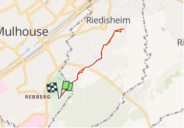

Length
5.6 km

Max alt
319 m

Uphill gradient
86 m
Km-Effort
6.8 km

Min alt
248 m

Downhill gradient
85 m
Boucle
Yes
Creation date :
2022-01-05 14:10:43.0
Updated on :
2022-01-05 15:46:15.533
1h25
Difficulty : Medium

FREE GPS app for hiking
 SityTrail
IGN / Geographical institutes
SityTrail Plus
The world is yours!
About
Trail Walking of 5.6 km to be discovered at Grand Est, Haut-Rhin, Mulhouse. This trail is proposed by jmbilger.
Positioning
Country:
France
Region :
Grand Est
Department/Province :
Haut-Rhin
Municipality :
Mulhouse
Location:
Unknown
Start:(Dec)
Start:(UTM)
376446 ; 5287799 (32T) N.
Comments