


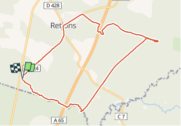
Retjons chapelle de lugaut

611686735
User

Length
10.9 km

Max alt
103 m

Uphill gradient
77 m
Km-Effort
11.9 km

Min alt
83 m

Downhill gradient
76 m
Boucle
Yes
Creation date :
2022-01-17 13:25:24.0
Updated on :
2022-01-17 16:11:57.152
2h45
Difficulty : Easy

FREE GPS app for hiking
 SityTrail
IGN / Geographical institutes
SityTrail Plus
The world is yours!
About
Trail Walking of 10.9 km to be discovered at New Aquitaine, Landes, Retjons. This trail is proposed by 611686735.
Positioning
Country:
France
Region :
New Aquitaine
Department/Province :
Landes
Municipality :
Retjons
Location:
Unknown
Start:(Dec)
Start:(UTM)
715471 ; 4885317 (30T) N.
Comments