


2022 01 21 home bio Group

jmbilger
User
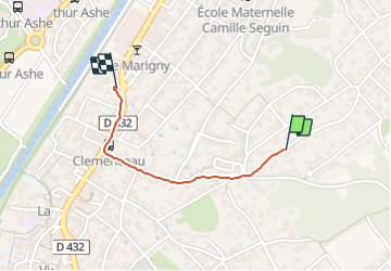

Length
826 m

Max alt
295 m

Uphill gradient
0 m
Km-Effort
989 m

Min alt
243 m

Downhill gradient
49 m
Boucle
No
Creation date :
2022-01-21 06:32:44.0
Updated on :
2022-01-24 13:09:09.505
11m
Difficulty : Easy

FREE GPS app for hiking
 SityTrail
IGN / Geographical institutes
SityTrail Plus
The world is yours!
About
Trail Walking of 826 m to be discovered at Grand Est, Haut-Rhin, Brunstatt-Didenheim. This trail is proposed by jmbilger.
Positioning
Country:
France
Region :
Grand Est
Department/Province :
Haut-Rhin
Municipality :
Brunstatt-Didenheim
Location:
Brunstatt
Start:(Dec)
Start:(UTM)
374471 ; 5286822 (32T) N.
Comments