Trail Walking Thairé - Thairé - Mortagne - Photo
© OpenStreetMap contributors
Length
Length
10.5 km
Max alt
Max alt
44 m
Uphill gradient
Uphill gradient
81 m
Km-Effort
Km-Effort  
11.6 km
Min alt
Min alt
5 m
Downhill gradient
Downhill gradient
81 m
Boucle
Boucle
Yes
Creation date :
2022-01-28 16:09:26.068
Updated on :
2022-01-28 17:04:33.075

(0 Reviews)

Walking
Walking
2h38
Difficulty : Medium

Scan this QR Code to open this trail in the SityTrail application

FREE GPS app for hiking

Logo SityTrail SityTrail

IGN / Geographical institutes

Download SityTrail from the App Store Download SityTrail from Google Play

Logo SityTrail SityTrail World

The world is yours!

Download SityTrail from the App Store Download SityTrail from Google Play Download SityTrail on Huawei AppGallery

About

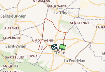
Trail Walking of 10.5 km to be discovered at New Aquitaine, Charente-Maritime, Thairé. This trail is proposed by Philippe17290.

Description

Emprunter la venelle (à gauche sous les arbres), prendre à gauche, puis à droite.
Prendre la route à gauche ( rue du  Meurier), puis la première à droite.

prendre à gauche vers la ferme des Coutures, puis à droite la départementale  sur 100m et à gauche un chemin herbeux.

A la sortie du chemin, traverser la route et prendre le chemin à gauche. Après la zone boisée, prendre à droite et poursuivre par le chemin des Majolières jusqu’à Mortagne.
Au stop prendre à gauche la départementale direction Salles / mer, la quitter pour un chemin empierré à droite , le suivre, prendre à gauche, puis à droite, pour traverser le petit bois de Bouban. tourner à droite sur le chemin de Ciré (ou de la marée), points de vue sur la mer et les iles, continuer en traversant la D110 (danger), puis après env 500 m . descendre à droite en direction du lieu dit "moulin de Lhoué". traverser la départementale, emprunter le chemin empierré pour rejoindre
Thairé.
suivre la rue du chêne vert, tourner à droite, puis la rue du clou, la rue du Temple, et la ruelle des jardins.  Enfin retrouver à gauche la venelle qui ramène sur la place.

Elevation profile

Positioning

Country:
France
Region :
New Aquitaine
Department/Province :
Charente-Maritime
Municipality :
Thairé
Location:
Unknown
Start:(UTM)
654377 ; 5104208 (30T) N.

Trails nearby

Trail Walking Yves - yves - Photo
Walking
penaud

Walking

Very easy
Yves, New Aquitaine, Charente-Maritime, France
3.3 km | 3.5 km-effort
1h 24min
No
Trail Walking Thairé - Autour de Thairé 10 km - Photo
Walking
Nadège17170

Walking

Easy
Thairé, New Aquitaine, Charente-Maritime, France
10 km | 11.1 km-effort
2h 24min
Yes
Trail Mountain bike Ciré-d'Aunis - Ha ! Charras 2 - Photo
Mountain bike
Marcel-le-cycliste

Mountain bike

Medium
Ciré-d'Aunis, New Aquitaine, Charente-Maritime, France
12.7 km | 13.4 km-effort
1h 21min
Yes
Trail Walking Yves - Yves , le bord de mer - Photo
Walking
micka2

Walking

Very easy
(1)
Yves, New Aquitaine, Charente-Maritime, France
8.6 km | 9.2 km-effort
2h 50min
Yes
Trail Walking Salles-sur-Mer - Salles-sur-mer - Photo
Walking
reva17

Walking

Easy
Salles-sur-Mer, New Aquitaine, Charente-Maritime, France
10.4 km | 11.4 km-effort
2h 31min
Yes
Trail Walking Thairé - Ballon - Photo
Walking
lemairealain

Walking

Easy
Thairé, New Aquitaine, Charente-Maritime, France
7.1 km | 7.7 km-effort
Unknown
Yes
Trail Walking Thairé - Thairé - Photo
Walking
lemairealain

Walking

Easy
Thairé, New Aquitaine, Charente-Maritime, France
9.1 km | 10 km-effort
Unknown
Yes
Trail Walking Thairé - Thairé Oignons  - Photo
Walking
Nadège17170

Walking

Medium
Thairé, New Aquitaine, Charente-Maritime, France
10.5 km | 11.5 km-effort
2h 34min
Yes
Trail Walking Thairé - Thairé 20230809 - Photo
Walking
pascal5477

Walking

Thairé, New Aquitaine, Charente-Maritime, France
10.3 km | 11.3 km-effort
2h 20min
Yes


Close
My subscriptions