


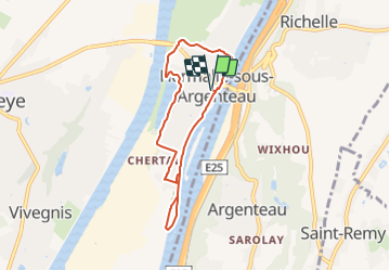

10.9 km | 12.6 km-effort

« L’heure de la fin des découvertes ne sonne jamais. » Colette GUIDE+


FREE GPS app for hiking
 SityTrail
IGN / Geographical institutes
SityTrail World
The world is yours!
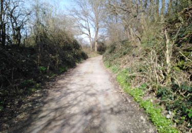
Trail Walking of 5.9 km to be discovered at Wallonia, Liège, Oupeye. This trail is proposed by Au fil de nos découvertes.
🅿️ Départ et Parking:
Place Gérard Froidmont
4681 Oupeye
▶️ Suivre la balise "rectangle vert"
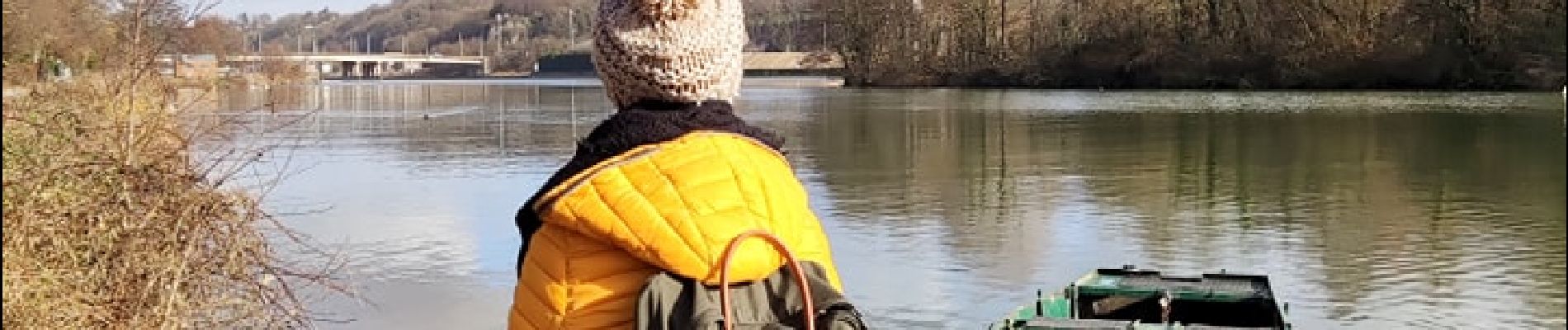
Vous commencerez la promenade en longeant la Meuse. 💦
Vous devriez croiser des canards ou des oies. 🦢🦆
Vous irez vers le Hemlot, un ancien bras de la Meuse, c'est assez mignon et vous pouvez y pique-niquer. 👌 (Passage difficile pour les poussettes)
Vous y ferez une boucle et reviendrez sur vos pas. 👣
En face de l'ile de Franche, vous irez à gauche, direction la Gravière.
La Gravière Brock est très riche en biodiversité, vous retrouverez d'ailleurs des panneaux explicatifs ainsi que des observatoires. 🌿🐸🦢🦋
Possibilités de pique-niquer. 🥪🍴
Chiens autorisés en laisse. 🐩🐶🐕
Convient pour les enfants . 👱👱♂️
Convient pour les poussettes mais pas pour les personnes à mobilité réduite. 👨🦽👩🦽👶
N'hésitez pas à aller faire un tour sur notre site internet et nos réseaux :
www.aufildenosdecouvertes.com
www.facebook.com/aufildenosdecouvertes
https://www.instagram.com/au_fil_de_nos_decouvertes/
 "
data-pinterest-text="Pin it"
data-tweet-text="share on twitter"
data-facebook-share-url="https://www.sitytrail.com/en/trails/3069601-oupeye--promenade-xhistoire-dxeaux/?photo=1#lg=1&slide=1"
data-twitter-share-url="https://www.sitytrail.com/en/trails/3069601-oupeye--promenade-xhistoire-dxeaux/?photo=1#lg=1&slide=1"
data-googleplus-share-url="https://www.sitytrail.com/en/trails/3069601-oupeye--promenade-xhistoire-dxeaux/?photo=1#lg=1&slide=1"
data-pinterest-share-url="https://www.sitytrail.com/en/trails/3069601-oupeye--promenade-xhistoire-dxeaux/?photo=1#lg=1&slide=1">
"
data-pinterest-text="Pin it"
data-tweet-text="share on twitter"
data-facebook-share-url="https://www.sitytrail.com/en/trails/3069601-oupeye--promenade-xhistoire-dxeaux/?photo=1#lg=1&slide=1"
data-twitter-share-url="https://www.sitytrail.com/en/trails/3069601-oupeye--promenade-xhistoire-dxeaux/?photo=1#lg=1&slide=1"
data-googleplus-share-url="https://www.sitytrail.com/en/trails/3069601-oupeye--promenade-xhistoire-dxeaux/?photo=1#lg=1&slide=1"
data-pinterest-share-url="https://www.sitytrail.com/en/trails/3069601-oupeye--promenade-xhistoire-dxeaux/?photo=1#lg=1&slide=1">
 "
data-pinterest-text="Pin it"
data-tweet-text="share on twitter"
data-facebook-share-url="https://www.sitytrail.com/en/trails/3069601-oupeye--promenade-xhistoire-dxeaux/?photo=2#lg=1&slide=2"
data-twitter-share-url="https://www.sitytrail.com/en/trails/3069601-oupeye--promenade-xhistoire-dxeaux/?photo=2#lg=1&slide=2"
data-googleplus-share-url="https://www.sitytrail.com/en/trails/3069601-oupeye--promenade-xhistoire-dxeaux/?photo=2#lg=1&slide=2"
data-pinterest-share-url="https://www.sitytrail.com/en/trails/3069601-oupeye--promenade-xhistoire-dxeaux/?photo=2#lg=1&slide=2">
"
data-pinterest-text="Pin it"
data-tweet-text="share on twitter"
data-facebook-share-url="https://www.sitytrail.com/en/trails/3069601-oupeye--promenade-xhistoire-dxeaux/?photo=2#lg=1&slide=2"
data-twitter-share-url="https://www.sitytrail.com/en/trails/3069601-oupeye--promenade-xhistoire-dxeaux/?photo=2#lg=1&slide=2"
data-googleplus-share-url="https://www.sitytrail.com/en/trails/3069601-oupeye--promenade-xhistoire-dxeaux/?photo=2#lg=1&slide=2"
data-pinterest-share-url="https://www.sitytrail.com/en/trails/3069601-oupeye--promenade-xhistoire-dxeaux/?photo=2#lg=1&slide=2">
 "
data-pinterest-text="Pin it"
data-tweet-text="share on twitter"
data-facebook-share-url="https://www.sitytrail.com/en/trails/3069601-oupeye--promenade-xhistoire-dxeaux/?photo=3#lg=1&slide=3"
data-twitter-share-url="https://www.sitytrail.com/en/trails/3069601-oupeye--promenade-xhistoire-dxeaux/?photo=3#lg=1&slide=3"
data-googleplus-share-url="https://www.sitytrail.com/en/trails/3069601-oupeye--promenade-xhistoire-dxeaux/?photo=3#lg=1&slide=3"
data-pinterest-share-url="https://www.sitytrail.com/en/trails/3069601-oupeye--promenade-xhistoire-dxeaux/?photo=3#lg=1&slide=3">
"
data-pinterest-text="Pin it"
data-tweet-text="share on twitter"
data-facebook-share-url="https://www.sitytrail.com/en/trails/3069601-oupeye--promenade-xhistoire-dxeaux/?photo=3#lg=1&slide=3"
data-twitter-share-url="https://www.sitytrail.com/en/trails/3069601-oupeye--promenade-xhistoire-dxeaux/?photo=3#lg=1&slide=3"
data-googleplus-share-url="https://www.sitytrail.com/en/trails/3069601-oupeye--promenade-xhistoire-dxeaux/?photo=3#lg=1&slide=3"
data-pinterest-share-url="https://www.sitytrail.com/en/trails/3069601-oupeye--promenade-xhistoire-dxeaux/?photo=3#lg=1&slide=3">
 "
data-pinterest-text="Pin it"
data-tweet-text="share on twitter"
data-facebook-share-url="https://www.sitytrail.com/en/trails/3069601-oupeye--promenade-xhistoire-dxeaux/?photo=4#lg=1&slide=4"
data-twitter-share-url="https://www.sitytrail.com/en/trails/3069601-oupeye--promenade-xhistoire-dxeaux/?photo=4#lg=1&slide=4"
data-googleplus-share-url="https://www.sitytrail.com/en/trails/3069601-oupeye--promenade-xhistoire-dxeaux/?photo=4#lg=1&slide=4"
data-pinterest-share-url="https://www.sitytrail.com/en/trails/3069601-oupeye--promenade-xhistoire-dxeaux/?photo=4#lg=1&slide=4">
"
data-pinterest-text="Pin it"
data-tweet-text="share on twitter"
data-facebook-share-url="https://www.sitytrail.com/en/trails/3069601-oupeye--promenade-xhistoire-dxeaux/?photo=4#lg=1&slide=4"
data-twitter-share-url="https://www.sitytrail.com/en/trails/3069601-oupeye--promenade-xhistoire-dxeaux/?photo=4#lg=1&slide=4"
data-googleplus-share-url="https://www.sitytrail.com/en/trails/3069601-oupeye--promenade-xhistoire-dxeaux/?photo=4#lg=1&slide=4"
data-pinterest-share-url="https://www.sitytrail.com/en/trails/3069601-oupeye--promenade-xhistoire-dxeaux/?photo=4#lg=1&slide=4">
 "
data-pinterest-text="Pin it"
data-tweet-text="share on twitter"
data-facebook-share-url="https://www.sitytrail.com/en/trails/3069601-oupeye--promenade-xhistoire-dxeaux/?photo=5#lg=1&slide=5"
data-twitter-share-url="https://www.sitytrail.com/en/trails/3069601-oupeye--promenade-xhistoire-dxeaux/?photo=5#lg=1&slide=5"
data-googleplus-share-url="https://www.sitytrail.com/en/trails/3069601-oupeye--promenade-xhistoire-dxeaux/?photo=5#lg=1&slide=5"
data-pinterest-share-url="https://www.sitytrail.com/en/trails/3069601-oupeye--promenade-xhistoire-dxeaux/?photo=5#lg=1&slide=5">
"
data-pinterest-text="Pin it"
data-tweet-text="share on twitter"
data-facebook-share-url="https://www.sitytrail.com/en/trails/3069601-oupeye--promenade-xhistoire-dxeaux/?photo=5#lg=1&slide=5"
data-twitter-share-url="https://www.sitytrail.com/en/trails/3069601-oupeye--promenade-xhistoire-dxeaux/?photo=5#lg=1&slide=5"
data-googleplus-share-url="https://www.sitytrail.com/en/trails/3069601-oupeye--promenade-xhistoire-dxeaux/?photo=5#lg=1&slide=5"
data-pinterest-share-url="https://www.sitytrail.com/en/trails/3069601-oupeye--promenade-xhistoire-dxeaux/?photo=5#lg=1&slide=5">
 "
data-pinterest-text="Pin it"
data-tweet-text="share on twitter"
data-facebook-share-url="https://www.sitytrail.com/en/trails/3069601-oupeye--promenade-xhistoire-dxeaux/?photo=6#lg=1&slide=6"
data-twitter-share-url="https://www.sitytrail.com/en/trails/3069601-oupeye--promenade-xhistoire-dxeaux/?photo=6#lg=1&slide=6"
data-googleplus-share-url="https://www.sitytrail.com/en/trails/3069601-oupeye--promenade-xhistoire-dxeaux/?photo=6#lg=1&slide=6"
data-pinterest-share-url="https://www.sitytrail.com/en/trails/3069601-oupeye--promenade-xhistoire-dxeaux/?photo=6#lg=1&slide=6">
"
data-pinterest-text="Pin it"
data-tweet-text="share on twitter"
data-facebook-share-url="https://www.sitytrail.com/en/trails/3069601-oupeye--promenade-xhistoire-dxeaux/?photo=6#lg=1&slide=6"
data-twitter-share-url="https://www.sitytrail.com/en/trails/3069601-oupeye--promenade-xhistoire-dxeaux/?photo=6#lg=1&slide=6"
data-googleplus-share-url="https://www.sitytrail.com/en/trails/3069601-oupeye--promenade-xhistoire-dxeaux/?photo=6#lg=1&slide=6"
data-pinterest-share-url="https://www.sitytrail.com/en/trails/3069601-oupeye--promenade-xhistoire-dxeaux/?photo=6#lg=1&slide=6">
 "
data-pinterest-text="Pin it"
data-tweet-text="share on twitter"
data-facebook-share-url="https://www.sitytrail.com/en/trails/3069601-oupeye--promenade-xhistoire-dxeaux/?photo=7#lg=1&slide=7"
data-twitter-share-url="https://www.sitytrail.com/en/trails/3069601-oupeye--promenade-xhistoire-dxeaux/?photo=7#lg=1&slide=7"
data-googleplus-share-url="https://www.sitytrail.com/en/trails/3069601-oupeye--promenade-xhistoire-dxeaux/?photo=7#lg=1&slide=7"
data-pinterest-share-url="https://www.sitytrail.com/en/trails/3069601-oupeye--promenade-xhistoire-dxeaux/?photo=7#lg=1&slide=7">
"
data-pinterest-text="Pin it"
data-tweet-text="share on twitter"
data-facebook-share-url="https://www.sitytrail.com/en/trails/3069601-oupeye--promenade-xhistoire-dxeaux/?photo=7#lg=1&slide=7"
data-twitter-share-url="https://www.sitytrail.com/en/trails/3069601-oupeye--promenade-xhistoire-dxeaux/?photo=7#lg=1&slide=7"
data-googleplus-share-url="https://www.sitytrail.com/en/trails/3069601-oupeye--promenade-xhistoire-dxeaux/?photo=7#lg=1&slide=7"
data-pinterest-share-url="https://www.sitytrail.com/en/trails/3069601-oupeye--promenade-xhistoire-dxeaux/?photo=7#lg=1&slide=7">
 "
data-pinterest-text="Pin it"
data-tweet-text="share on twitter"
data-facebook-share-url="https://www.sitytrail.com/en/trails/3069601-oupeye--promenade-xhistoire-dxeaux/?photo=8#lg=1&slide=8"
data-twitter-share-url="https://www.sitytrail.com/en/trails/3069601-oupeye--promenade-xhistoire-dxeaux/?photo=8#lg=1&slide=8"
data-googleplus-share-url="https://www.sitytrail.com/en/trails/3069601-oupeye--promenade-xhistoire-dxeaux/?photo=8#lg=1&slide=8"
data-pinterest-share-url="https://www.sitytrail.com/en/trails/3069601-oupeye--promenade-xhistoire-dxeaux/?photo=8#lg=1&slide=8">
"
data-pinterest-text="Pin it"
data-tweet-text="share on twitter"
data-facebook-share-url="https://www.sitytrail.com/en/trails/3069601-oupeye--promenade-xhistoire-dxeaux/?photo=8#lg=1&slide=8"
data-twitter-share-url="https://www.sitytrail.com/en/trails/3069601-oupeye--promenade-xhistoire-dxeaux/?photo=8#lg=1&slide=8"
data-googleplus-share-url="https://www.sitytrail.com/en/trails/3069601-oupeye--promenade-xhistoire-dxeaux/?photo=8#lg=1&slide=8"
data-pinterest-share-url="https://www.sitytrail.com/en/trails/3069601-oupeye--promenade-xhistoire-dxeaux/?photo=8#lg=1&slide=8">
 "
data-pinterest-text="Pin it"
data-tweet-text="share on twitter"
data-facebook-share-url="https://www.sitytrail.com/en/trails/3069601-oupeye--promenade-xhistoire-dxeaux/?photo=9#lg=1&slide=9"
data-twitter-share-url="https://www.sitytrail.com/en/trails/3069601-oupeye--promenade-xhistoire-dxeaux/?photo=9#lg=1&slide=9"
data-googleplus-share-url="https://www.sitytrail.com/en/trails/3069601-oupeye--promenade-xhistoire-dxeaux/?photo=9#lg=1&slide=9"
data-pinterest-share-url="https://www.sitytrail.com/en/trails/3069601-oupeye--promenade-xhistoire-dxeaux/?photo=9#lg=1&slide=9">
"
data-pinterest-text="Pin it"
data-tweet-text="share on twitter"
data-facebook-share-url="https://www.sitytrail.com/en/trails/3069601-oupeye--promenade-xhistoire-dxeaux/?photo=9#lg=1&slide=9"
data-twitter-share-url="https://www.sitytrail.com/en/trails/3069601-oupeye--promenade-xhistoire-dxeaux/?photo=9#lg=1&slide=9"
data-googleplus-share-url="https://www.sitytrail.com/en/trails/3069601-oupeye--promenade-xhistoire-dxeaux/?photo=9#lg=1&slide=9"
data-pinterest-share-url="https://www.sitytrail.com/en/trails/3069601-oupeye--promenade-xhistoire-dxeaux/?photo=9#lg=1&slide=9">
 "
data-pinterest-text="Pin it"
data-tweet-text="share on twitter"
data-facebook-share-url="https://www.sitytrail.com/en/trails/3069601-oupeye--promenade-xhistoire-dxeaux/?photo=10#lg=1&slide=10"
data-twitter-share-url="https://www.sitytrail.com/en/trails/3069601-oupeye--promenade-xhistoire-dxeaux/?photo=10#lg=1&slide=10"
data-googleplus-share-url="https://www.sitytrail.com/en/trails/3069601-oupeye--promenade-xhistoire-dxeaux/?photo=10#lg=1&slide=10"
data-pinterest-share-url="https://www.sitytrail.com/en/trails/3069601-oupeye--promenade-xhistoire-dxeaux/?photo=10#lg=1&slide=10">
"
data-pinterest-text="Pin it"
data-tweet-text="share on twitter"
data-facebook-share-url="https://www.sitytrail.com/en/trails/3069601-oupeye--promenade-xhistoire-dxeaux/?photo=10#lg=1&slide=10"
data-twitter-share-url="https://www.sitytrail.com/en/trails/3069601-oupeye--promenade-xhistoire-dxeaux/?photo=10#lg=1&slide=10"
data-googleplus-share-url="https://www.sitytrail.com/en/trails/3069601-oupeye--promenade-xhistoire-dxeaux/?photo=10#lg=1&slide=10"
data-pinterest-share-url="https://www.sitytrail.com/en/trails/3069601-oupeye--promenade-xhistoire-dxeaux/?photo=10#lg=1&slide=10">
 "
data-pinterest-text="Pin it"
data-tweet-text="share on twitter"
data-facebook-share-url="https://www.sitytrail.com/en/trails/3069601-oupeye--promenade-xhistoire-dxeaux/?photo=11#lg=1&slide=11"
data-twitter-share-url="https://www.sitytrail.com/en/trails/3069601-oupeye--promenade-xhistoire-dxeaux/?photo=11#lg=1&slide=11"
data-googleplus-share-url="https://www.sitytrail.com/en/trails/3069601-oupeye--promenade-xhistoire-dxeaux/?photo=11#lg=1&slide=11"
data-pinterest-share-url="https://www.sitytrail.com/en/trails/3069601-oupeye--promenade-xhistoire-dxeaux/?photo=11#lg=1&slide=11">
"
data-pinterest-text="Pin it"
data-tweet-text="share on twitter"
data-facebook-share-url="https://www.sitytrail.com/en/trails/3069601-oupeye--promenade-xhistoire-dxeaux/?photo=11#lg=1&slide=11"
data-twitter-share-url="https://www.sitytrail.com/en/trails/3069601-oupeye--promenade-xhistoire-dxeaux/?photo=11#lg=1&slide=11"
data-googleplus-share-url="https://www.sitytrail.com/en/trails/3069601-oupeye--promenade-xhistoire-dxeaux/?photo=11#lg=1&slide=11"
data-pinterest-share-url="https://www.sitytrail.com/en/trails/3069601-oupeye--promenade-xhistoire-dxeaux/?photo=11#lg=1&slide=11">
 "
data-pinterest-text="Pin it"
data-tweet-text="share on twitter"
data-facebook-share-url="https://www.sitytrail.com/en/trails/3069601-oupeye--promenade-xhistoire-dxeaux/?photo=12#lg=1&slide=12"
data-twitter-share-url="https://www.sitytrail.com/en/trails/3069601-oupeye--promenade-xhistoire-dxeaux/?photo=12#lg=1&slide=12"
data-googleplus-share-url="https://www.sitytrail.com/en/trails/3069601-oupeye--promenade-xhistoire-dxeaux/?photo=12#lg=1&slide=12"
data-pinterest-share-url="https://www.sitytrail.com/en/trails/3069601-oupeye--promenade-xhistoire-dxeaux/?photo=12#lg=1&slide=12">
"
data-pinterest-text="Pin it"
data-tweet-text="share on twitter"
data-facebook-share-url="https://www.sitytrail.com/en/trails/3069601-oupeye--promenade-xhistoire-dxeaux/?photo=12#lg=1&slide=12"
data-twitter-share-url="https://www.sitytrail.com/en/trails/3069601-oupeye--promenade-xhistoire-dxeaux/?photo=12#lg=1&slide=12"
data-googleplus-share-url="https://www.sitytrail.com/en/trails/3069601-oupeye--promenade-xhistoire-dxeaux/?photo=12#lg=1&slide=12"
data-pinterest-share-url="https://www.sitytrail.com/en/trails/3069601-oupeye--promenade-xhistoire-dxeaux/?photo=12#lg=1&slide=12">
 "
data-pinterest-text="Pin it"
data-tweet-text="share on twitter"
data-facebook-share-url="https://www.sitytrail.com/en/trails/3069601-oupeye--promenade-xhistoire-dxeaux/?photo=13#lg=1&slide=13"
data-twitter-share-url="https://www.sitytrail.com/en/trails/3069601-oupeye--promenade-xhistoire-dxeaux/?photo=13#lg=1&slide=13"
data-googleplus-share-url="https://www.sitytrail.com/en/trails/3069601-oupeye--promenade-xhistoire-dxeaux/?photo=13#lg=1&slide=13"
data-pinterest-share-url="https://www.sitytrail.com/en/trails/3069601-oupeye--promenade-xhistoire-dxeaux/?photo=13#lg=1&slide=13">
"
data-pinterest-text="Pin it"
data-tweet-text="share on twitter"
data-facebook-share-url="https://www.sitytrail.com/en/trails/3069601-oupeye--promenade-xhistoire-dxeaux/?photo=13#lg=1&slide=13"
data-twitter-share-url="https://www.sitytrail.com/en/trails/3069601-oupeye--promenade-xhistoire-dxeaux/?photo=13#lg=1&slide=13"
data-googleplus-share-url="https://www.sitytrail.com/en/trails/3069601-oupeye--promenade-xhistoire-dxeaux/?photo=13#lg=1&slide=13"
data-pinterest-share-url="https://www.sitytrail.com/en/trails/3069601-oupeye--promenade-xhistoire-dxeaux/?photo=13#lg=1&slide=13">


Walking

Walking

Walking

Walking
Walking

Walking
Walking
Beau parcours au fil de l'eau ... la Meuse et le lac de la Gravière Brock. Avec Luna 🐕
Top 👌🏼