


mittelwihr

jcschubnel
User
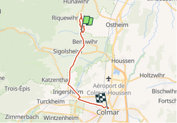

Length
17 km

Max alt
282 m

Uphill gradient
157 m
Km-Effort
19.2 km

Min alt
189 m

Downhill gradient
184 m
Boucle
No
Creation date :
2022-02-05 13:27:34.467
Updated on :
2022-02-05 16:12:58.467
2h02
Difficulty : Very easy

FREE GPS app for hiking
 SityTrail
IGN / Geographical institutes
SityTrail Plus
The world is yours!
About
Trail Walking of 17 km to be discovered at Grand Est, Haut-Rhin, Mittelwihr. This trail is proposed by jcschubnel.
Positioning
Country:
France
Region :
Grand Est
Department/Province :
Haut-Rhin
Municipality :
Mittelwihr
Location:
Unknown
Start:(Dec)
Start:(UTM)
375137 ; 5334637 (32U) N.
Comments