


Soultz

jcschubnel
User

Length
3.6 km

Max alt
358 m

Uphill gradient
73 m
Km-Effort
4.6 km

Min alt
290 m

Downhill gradient
74 m
Boucle
Yes
Creation date :
2022-02-05 14:37:40.21
Updated on :
2022-02-05 16:29:39.415
59m
Difficulty : Easy

FREE GPS app for hiking
 SityTrail
IGN / Geographical institutes
SityTrail Plus
The world is yours!
About
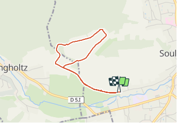
Trail Walking of 3.6 km to be discovered at Grand Est, Haut-Rhin, Soultz-Haut-Rhin. This trail is proposed by jcschubnel.
Positioning
Country:
France
Region :
Grand Est
Department/Province :
Haut-Rhin
Municipality :
Soultz-Haut-Rhin
Location:
Unknown
Start:(Dec)
Start:(UTM)
366591 ; 5304773 (32T) N.
Comments