Trail On foot Bouillon - Panorama de Frahan à Rochehaut - Photo

Panorama de Frahan à Rochehaut

Randonnées du CGT GUIDE+

© OpenStreetMap contributors
Length
Length
8.4 km
Max alt
Max alt
379 m
Uphill gradient
Uphill gradient
225 m
Km-Effort
Km-Effort  
11.4 km
Min alt
Min alt
206 m
Downhill gradient
Downhill gradient
229 m
Boucle
Boucle
Yes
Creation date :
2022-02-08 11:27:49.985
Updated on :
2022-02-21 10:09:00.42

(2 Reviews)

On foot
On foot
2h35
Difficulty : Easy

Scan this QR Code to open this trail in the SityTrail application

FREE GPS app for hiking

Logo SityTrail SityTrail

IGN / Geographical institutes

Download SityTrail from the App Store Download SityTrail from Google Play

Logo SityTrail SityTrail World

The world is yours!

Download SityTrail from the App Store Download SityTrail from Google Play Download SityTrail on Huawei AppGallery

About

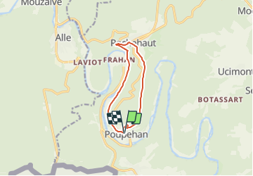
Trail On foot of 8.4 km to be discovered at Wallonia, Luxembourg, Bouillon. This trail is proposed by Commissariat général au Tourisme.

Description

Trail created by Pays de Bouillon en Ardenne.


Beautiful historical route linking Poupehan to Rochehaut via the old Bouillon road. In Rochehaut, admire the church, the house of Marie Howet and the magnificent panarama of Frahan. At the footbridge of Frahan, do not hesitate to make a small diversions in this charming village. The return journey is along the romantic route along the Semois. You can take a break on the rocks and relax by the water.


In winter, the path along the Semois is sometimes flooded, a deviation (by a path) not marked out at the level of the stream (after 6 km) is possible.


Elevation profile

Photos

Positioning

Country:
Belgium
Region :
Wallonia
Department/Province :
Luxembourg
Municipality :
Bouillon
Location:
Unknown
Start:(UTM)
644100 ; 5519637 (31U) N.

Comments

Please log in to post a review or rate the element


Trails nearby

Trail Walking Bouillon - RB-LUX-13 - Les belvédères bouillonnais - Photo
Walking
PRO

Walking

Medium
(7)
Bouillon, Wallonia, Luxembourg, Belgium
20 km | 30 km-effort
5h 55min
Yes
Trail Walking Vresse-sur-Semois - Rb-Na-32-Racc_Sur-les-rampes-escarpées-de-la-vallée-de-la-Semois - Photo
Walking
PRO

Walking

Very difficult
(2)
Vresse-sur-Semois, Wallonia, Namur, Belgium
14.7 km | 23 km-effort
5h 14min
Yes
Trail Walking Vresse-sur-Semois - Rb-Na-32_Sur les rampes escarpées de la vallée de la Semois - Photo
Walking
PRO

Walking

Very difficult
(2)
Vresse-sur-Semois, Wallonia, Namur, Belgium
19.8 km | 31 km-effort
7h 5min
Yes
Trail Walking Bouillon - RB-LUX-13 - Raccourci - Les belvédères bouillonnais - Photo
Walking
PRO

Walking

Medium
(4)
Bouillon, Wallonia, Luxembourg, Belgium
16.7 km | 25 km-effort
4h 54min
Yes
Trail Walking Bouillon - De Corbion à la Roche aux Eperviers - Photo
Walking
GUIDE
Desrumaux

Walking

Easy
(1)
Bouillon, Wallonia, Luxembourg, Belgium
10.6 km | 14.6 km-effort
2h 50min
Yes
Trail Walking Bouillon - De Poupehan à Frahan par le sentier des crêtes - Photo
Walking
GUIDE
Desrumaux

Walking

Medium
(2)
Bouillon, Wallonia, Luxembourg, Belgium
8.8 km | 12.5 km-effort
3h 0min
Yes
Trail Walking Bouillon - De Corbion à Poupehan par la Roche des Fées et la Chaire à Prêcher - Photo
Walking
GUIDE
Desrumaux

Walking

Medium
(2)
Bouillon, Wallonia, Luxembourg, Belgium
7.3 km | 11.1 km-effort
3h 0min
Yes
Trail Walking Bouillon - Corbion - Le Sentier des Points de Vue - Photo
Walking
GUIDE
Desrumaux

Walking

Medium
(7)
Bouillon, Wallonia, Luxembourg, Belgium
8.6 km | 12.2 km-effort
3h 0min
Yes
Trail Walking Bouillon - Promenade vers la Passerelle de l’épine  - Photo
Walking
GUIDE+

Walking

Medium
(6)
Bouillon, Wallonia, Luxembourg, Belgium
7.3 km | 11.2 km-effort
2h 33min
Yes


Close
My subscriptions