Trail On foot Erquelinnes - Promenade de la Haute Sambre - Photo

Promenade de la Haute Sambre

Randonnées du CGT GUIDE+

© OpenStreetMap contributors
Length
Length
9 km
Max alt
Max alt
180 m
Uphill gradient
Uphill gradient
89 m
Km-Effort
Km-Effort  
10.2 km
Min alt
Min alt
122 m
Downhill gradient
Downhill gradient
88 m
Boucle
Boucle
Yes
Creation date :
2022-02-08 11:37:24.045
Updated on :
2022-02-21 10:18:52.937

(0 Reviews)

On foot
On foot
2h18
Difficulty : Easy

Scan this QR Code to open this trail in the SityTrail application

FREE GPS app for hiking

Logo SityTrail SityTrail

IGN / Geographical institutes

Download SityTrail from the App Store Download SityTrail from Google Play

Logo SityTrail SityTrail World

The world is yours!

Download SityTrail from the App Store Download SityTrail from Google Play Download SityTrail on Huawei AppGallery

About

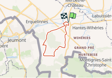
Trail On foot of 9 km to be discovered at Wallonia, Hainaut, Erquelinnes. This trail is proposed by Commissariat général au Tourisme.

Description

Trail created by Pays des Lacs.


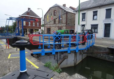
This itinerary begins at the foot of the fortified castle in Solre-sur-Sambre. Located at the meeting point of the Thure and Sambre rivers, the castle’s construction dates to the early 14th century. The castle defended the border. A testament to the Mediaeval military architecture of Hainaut, the castle has retained its quadrilateral design, with circular towers highlighting the four angles. The Thure river supplies the water for its moats. The Church of Saint-Médard stands proudly at the curve of the path that circles the castle and straddles the Thure. On the second Sunday in June, Saint-Médard accompanies the procession during the Entre-Sambre-et Meuse folk march. Once you reach the main road, pause before the bell tower farmhouse. It was erected in 1792 and its tower is a listed building. After crossing the fields bordering the woods, you can discover the Thure Abbey farmhouse, the last remaining vestige of an Augustinian canonesses’ abbey that was founded in the 13th century.


Elevation profile

Photos

Positioning

Country:
Belgium
Region :
Wallonia
Department/Province :
Hainaut
Municipality :
Erquelinnes
Location:
Unknown
Start:(UTM)
582368 ; 5573660 (31U) N.

Trails nearby

Trail Walking Merbes-le-Château - GG-Ht-05_Labuissière - Landelies - Photo
Walking
PRO

Walking

Very difficult
(1)
Merbes-le-Château, Wallonia, Hainaut, Belgium
21 km | 26 km-effort
5h 33min
No
Trail Walking Merbes-le-Château - RB-Ha-12 - Dans le parc naturel des Hauts-Pays - Photo
Walking
PRO

Walking

Very difficult
(2)
Merbes-le-Château, Wallonia, Hainaut, Belgium
23 km | 27 km-effort
6h 6min
Yes
Trail Walking Merbes-le-Château - De Merbes-le-Château à Labuissière - Photo
Walking
GUIDE
Desrumaux

Walking

Easy
(2)
Merbes-le-Château, Wallonia, Hainaut, Belgium
13.2 km | 14.8 km-effort
3h 15min
Yes
Trail Walking Merbes-le-Château - De Labuissiere vers Fontaine-Valmont par la Vallee de la Sambre - Photo
Walking
GUIDE
Desrumaux

Walking

Easy
(1)
Merbes-le-Château, Wallonia, Hainaut, Belgium
9.2 km | 10.8 km-effort
2h 15min
Yes
Trail Nordic walking Erquelinnes - 6560-05 - Hantes-Wihéries - 9,9km - 104m - Photo
Nordic walking

Nordic walking

Very easy
(1)
Erquelinnes, Wallonia, Hainaut, Belgium
9.9 km | 11.3 km-effort
Unknown
Yes
Trail On foot Lobbes - Promenade de Landelin - Photo
On foot
GUIDE+

On foot

Easy
Lobbes, Wallonia, Hainaut, Belgium
6.3 km | 7.2 km-effort
1h 37min
Yes
Trail On foot Erquelinnes - Sur les traces de la frontière hollandaise - Photo
On foot
GUIDE+

On foot

Easy
Erquelinnes, Wallonia, Hainaut, Belgium
6.9 km | 8.2 km-effort
1h 51min
Yes
Trail On foot Merbes-le-Château - Promenade des Batelières - Photo
On foot
GUIDE+

On foot

Easy
Merbes-le-Château, Wallonia, Hainaut, Belgium
4.5 km | 5.1 km-effort
1h 9min
Yes
Trail On foot Merbes-le-Château - Promenade de l’Éclusier - Photo
On foot
GUIDE+

On foot

Easy
Merbes-le-Château, Wallonia, Hainaut, Belgium
5.8 km | 6.5 km-effort
1h 29min
Yes


Close
My subscriptions