Trail On foot Merbes-le-Château - Promenade de l’Éclusier - Photo

Promenade de l’Éclusier

Randonnées du CGT GUIDE+

© OpenStreetMap contributors
Length
Length
5.8 km
Max alt
Max alt
149 m
Uphill gradient
Uphill gradient
54 m
Km-Effort
Km-Effort  
6.5 km
Min alt
Min alt
117 m
Downhill gradient
Downhill gradient
55 m
Boucle
Boucle
Yes
Creation date :
2022-02-08 11:22:10.302
Updated on :
2022-02-21 10:03:18.279

(0 Reviews)

On foot
On foot
1h29
Difficulty : Easy

Scan this QR Code to open this trail in the SityTrail application

FREE GPS app for hiking

Logo SityTrail SityTrail

IGN / Geographical institutes

Download SityTrail from the App Store Download SityTrail from Google Play

Logo SityTrail SityTrail World

The world is yours!

Download SityTrail from the App Store Download SityTrail from Google Play Download SityTrail on Huawei AppGallery

About

Trail On foot of 5.8 km to be discovered at Wallonia, Hainaut, Merbes-le-Château. This trail is proposed by Commissariat général au Tourisme.

Description

Trail created by Pays des Lacs.


Start near the Mosan Gothic-style Church of Saint-Martin, which has been listed since 1970. It boasts a bulbous bell tower and a 15th-century tabernacle. Follow a narrow path that provides access to the trail to ‘Gros Rouloy’. This itinerary is popular for its humid grasslands. Part of the Sambre river is ‘Natura 2000’-listed, due to the exceptional flora and fauna found there. Tarpans and a Shetland pony help to maintain the reserve without mechanical assistance. The wetlands are a site used by aquatic birds, as well as the northern crested newt, for breeding, migration and overwintering. Small white and yellow water lilies add a pretty splash of colour to the landscape.


Elevation profile

Photos

Positioning

Country:
Belgium
Region :
Wallonia
Department/Province :
Hainaut
Municipality :
Merbes-le-Château
Location:
Unknown
Start:(UTM)
583065 ; 5575397 (31U) N.

Trails nearby

Trail Walking Merbes-le-Château - GG-Ht-05_Labuissière - Landelies - Photo
Walking
PRO

Walking

Very difficult
(1)
Merbes-le-Château, Wallonia, Hainaut, Belgium
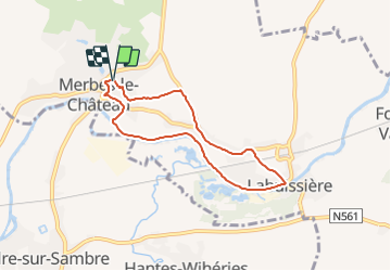
21 km | 26 km-effort
5h 33min
No
Trail Walking Merbes-le-Château - RB-Ha-12 - Dans le parc naturel des Hauts-Pays - Photo
Walking
PRO

Walking

Very difficult
(2)
Merbes-le-Château, Wallonia, Hainaut, Belgium
23 km | 27 km-effort
6h 6min
Yes
Trail Walking Merbes-le-Château - De Merbes-le-Château à Labuissière - Photo
Walking
GUIDE
Desrumaux

Walking

Easy
(2)
Merbes-le-Château, Wallonia, Hainaut, Belgium
13.2 km | 14.8 km-effort
3h 15min
Yes
Trail Walking Merbes-le-Château - De Labuissiere vers Fontaine-Valmont par la Vallee de la Sambre - Photo
Walking
GUIDE
Desrumaux

Walking

Easy
(1)
Merbes-le-Château, Wallonia, Hainaut, Belgium
9.2 km | 10.8 km-effort
2h 15min
Yes
Trail Nordic walking Erquelinnes - 6560-05 - Hantes-Wihéries - 9,9km - 104m - Photo
Nordic walking

Nordic walking

Very easy
(1)
Erquelinnes, Wallonia, Hainaut, Belgium
9.9 km | 11.3 km-effort
Unknown
Yes
Trail On foot Lobbes - Promenade de Landelin - Photo
On foot
GUIDE+

On foot

Easy
Lobbes, Wallonia, Hainaut, Belgium
6.3 km | 7.2 km-effort
1h 37min
Yes
Trail On foot Erquelinnes - Promenade de la Haute Sambre - Photo
On foot
GUIDE+

On foot

Easy
Erquelinnes, Wallonia, Hainaut, Belgium
9 km | 10.2 km-effort
2h 18min
Yes
Trail On foot Merbes-le-Château - Promenade des Batelières - Photo
On foot
GUIDE+

On foot

Easy
Merbes-le-Château, Wallonia, Hainaut, Belgium
4.5 km | 5.1 km-effort
1h 9min
Yes
Trail On foot Erquelinnes - Chemin de terre et de Sambre - Photo
On foot
GUIDE+

On foot

Easy
Erquelinnes, Wallonia, Hainaut, Belgium
8.4 km | 9.4 km-effort
2h 8min
Yes


Close
My subscriptions