Trail Walking Theux - Chemin des Sources |stage 7 JEHANSTER - THEUX - Photo

Chemin des Sources |stage 7 JEHANSTER - THEUX

Découvrez votre nature PRO

© OpenStreetMap contributors
Length
Length
15.2 km
Max alt
Max alt
348 m
Uphill gradient
Uphill gradient
249 m
Km-Effort
Km-Effort  
19.2 km
Min alt
Min alt
160 m
Downhill gradient
Downhill gradient
430 m
Boucle
Boucle
No
Creation date :
2022-02-08 13:45:43.86
Updated on :
2024-01-12 15:11:56.848

(1 Reviews)

Walking
Walking
4h21
Difficulty : Very difficult

Scan this QR Code to open this trail in the SityTrail application

FREE GPS app for hiking

Logo SityTrail SityTrail

IGN / Geographical institutes

Download SityTrail from the App Store Download SityTrail from Google Play

Logo SityTrail SityTrail World

The world is yours!

Download SityTrail from the App Store Download SityTrail from Google Play Download SityTrail on Huawei AppGallery

About

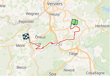
Trail Walking of 15.2 km to be discovered at Wallonia, Liège, Theux. This trail is proposed by Chemin des Sources.

Description

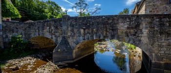
This stage takes us back to the Hoëgne valley, which passes through the village of Polleur with its beautifully restored houses and its old listed bridge.

The trail will bring you higher up to new magnificent views of the "Fenêtre de Theux", a well-known geological phenomenon. The small medieval town of Theux will not fail to delight you with its historic centre, its Perron and the Château de Franchimont.

Elevation profile

Photos

Points of interest

Point of interest Theux - The old bridge of Polleur  - Photo
Chemin des Sources
Point of interest Theux -  Franchimont Castle - Photo
Chemin des Sources
Point of interest Theux - the perron - Photo
Chemin des Sources
THEUX 
Point of interest Theux - FINISH - Photo
Supersylvain
THEUX 

Positioning

Country:
Belgium
Region :
Wallonia
Department/Province :
Liège
Municipality :
Theux
Location:
Polleur
Start:(Dec)
Start:(UTM)
705591 ; 5604531 (31U) N.

Comments

Please log in to post a review or rate the element


Une superbe étape campagnarde.


Trails nearby

Trail Walking Jalhay - Solwaster. Natura 2000, des sites qui valent le détour. Lg8 - Photo
Walking
GUIDE+

Walking

Difficult
(9)
Jalhay, Wallonia, Liège, Belgium
6.8 km | 9.1 km-effort
1h 58min
Yes
Trail Walking Verviers - Grand vivier - Cossart - Photo
Walking
simoan

Walking

Easy
(5)
Verviers, Wallonia, Liège, Belgium
4.7 km | 6.4 km-effort
1h 26min
Yes
Trail Walking Jalhay - La Gileppe - Bois de la Borchêne  - Photo
Walking
GUIDE
mumu.larandonneuse

Walking

Easy
(2)
Jalhay, Wallonia, Liège, Belgium
7.6 km | 9.8 km-effort
2h 13min
Yes
Trail Walking Theux - 20220901 - Jehanster 5.3 Km - Photo
Walking
GUIDE
pierreh01

Walking

Medium
(1)
Theux, Wallonia, Liège, Belgium
5.3 km | 6.8 km-effort
1h 32min
Yes
Trail Walking Jalhay - 2021-11-16_21h27m43_Cirkwi-Balade_à_Jalhay-Royompré_-_47 - Photo
Walking
GUIDE
mumu.larandonneuse

Walking

Easy
(2)
Jalhay, Wallonia, Liège, Belgium
11 km | 13.9 km-effort
3h 9min
Yes
Trail Walking Jalhay - 2021-11-16_21h12m11_Cirkwi-Solwaster_Sawe_-_balade_56_B (1) - Photo
Walking
GUIDE
mumu.larandonneuse

Walking

Medium
(2)
Jalhay, Wallonia, Liège, Belgium
8.5 km | 11.4 km-effort
2h 36min
Yes
Trail Walking Jalhay - 20210205 - La Gileppe 7.3 Km - Photo
Walking
GUIDE
pierreh01

Walking

Medium
(1)
Jalhay, Wallonia, Liège, Belgium
7.6 km | 9.9 km-effort
2h 24min
Yes
Trail Walking Limbourg - 20200606 - Hèvremont 8 Km - Photo
Walking
GUIDE
pierreh01

Walking

Difficult
(1)
Limbourg, Wallonia, Liège, Belgium
7.9 km | 10.7 km-effort
1h 34min
Yes
Trail Running Jalhay - Jalhay-Trail-26km - Photo
Running
florkin

Running

Difficult
(9)
Jalhay, Wallonia, Liège, Belgium
26 km | 34 km-effort
3h 0min
Yes


Close
My subscriptions