Trail Touring skiing Villar-d'Arêne - sous la brèche de la plate des agneaux  - Photo

sous la brèche de la plate des agneaux

 tchoua
tchoua

User

© OpenStreetMap contributors
Length
Length
21 km
Max alt
Max alt
2952 m
Uphill gradient
Uphill gradient
1313 m
Km-Effort
Km-Effort  
39 km
Min alt
Min alt
1668 m
Downhill gradient
Downhill gradient
1315 m
Boucle
Boucle
Yes
Creation date :
2022-02-08 07:23:12.103
Updated on :
2023-03-29 07:52:42.879

(0 Reviews)

Touring skiing
Touring skiing
5h14
Difficulty : Very easy

Scan this QR Code to open this trail in the SityTrail application

FREE GPS app for hiking

Logo SityTrail SityTrail

IGN / Geographical institutes

Download SityTrail from the App Store Download SityTrail from Google Play

Logo SityTrail SityTrail World

The world is yours!

Download SityTrail from the App Store Download SityTrail from Google Play Download SityTrail on Huawei AppGallery

About

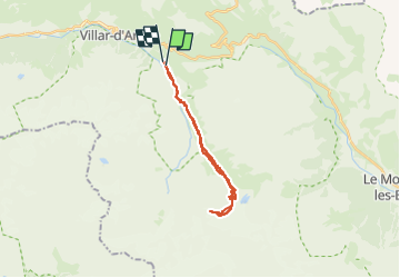
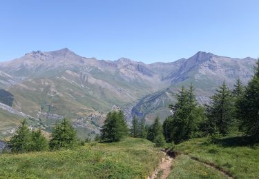
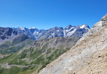
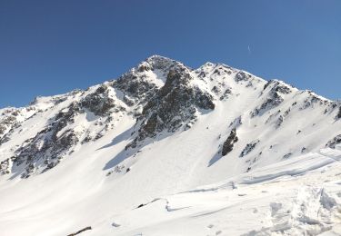
Trail Touring skiing of 21 km to be discovered at Provence-Alpes-Côte d'Azur, Hautes-Alpes, Villar-d'Arêne. This trail is proposed by tchoua.

Description

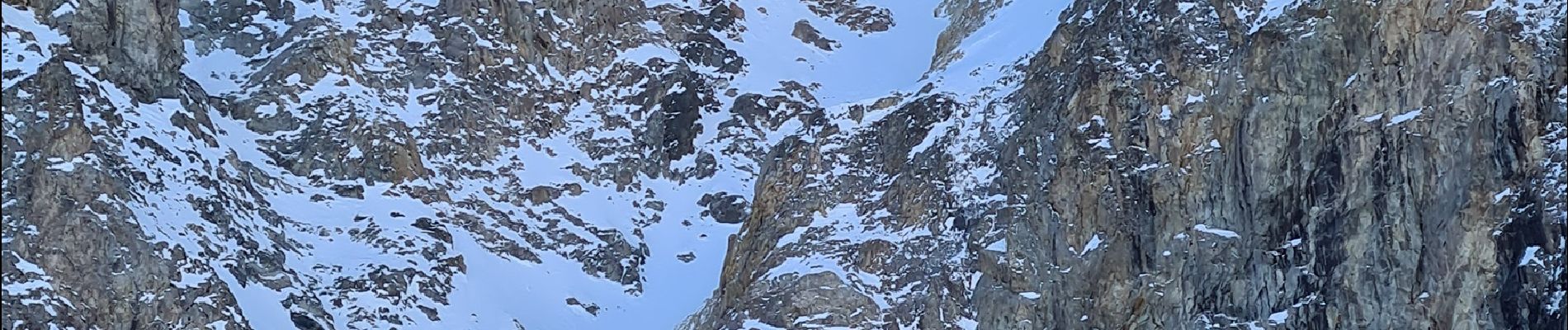
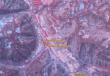
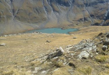
Au dessus du refuge de l alpe rester bien à droite sans prendre les premières pentes qui mènent au glacier de Chamoissiere continuer et dépasser l entrée des glaciers du dragon et du rif de la planche , qu on laisse à droite on se trouve devant une énorme moraine qui fait un large virage vers la gauche puis revient vers la droite au fond monter sur celle ci on domine alors tout le glacier d arsine ainsi que les lacs  la suivre jusqu’au bout vous serez sous la brèche Clothilde qui sert de passage entre le glacier d arsine et celui du rif de la planche , en face vous avez la brèche de la plate des agneaux et le bien nommé Neige Cordier

Elevation profile

Photos

Positioning

Country:
France
Region :
Provence-Alpes-Côte d'Azur
Department/Province :
Hautes-Alpes
Municipality :
Villar-d'Arêne
Location:
Unknown
Start:(UTM)
292391 ; 4989593 (32T) N.

Trails nearby

Trail Walking La Grave - L'aiguille du Goléon - Photo
Walking
tracegps

Walking

Very difficult
(1)
La Grave, Provence-Alpes-Côte d'Azur, Hautes-Alpes, France
9.1 km | 25 km-effort
5h 0min
No
Trail Walking La Grave - vallons de la Meije : lac Puy Vachère - Photo
Walking
GUIDE
nadinebondoux

Walking

Very difficult
La Grave, Provence-Alpes-Côte d'Azur, Hautes-Alpes, France
12.7 km | 27 km-effort
5h 44min
Yes
Trail Walking Villar-d'Arêne - Lac d'Arsine  - Photo
Walking
GUIDE
nadinebondoux

Walking

Difficult
Villar-d'Arêne, Provence-Alpes-Côte d'Azur, Hautes-Alpes, France
17.2 km | 28 km-effort
5h 37min
Yes
Trail Walking Le Monêtier-les-Bains - Pic Blanc du Galibier - Photo
Walking
GUIDE
amiral13

Walking

Medium
Le Monêtier-les-Bains, Provence-Alpes-Côte d'Azur, Hautes-Alpes, France
4.3 km | 9.9 km-effort
2h 51min
Yes
Trail Walking Villar-d'Arêne - SityTrail - Lac du pontet et l'Aiguillon - Photo
Walking

Walking

Medium
(1)
Villar-d'Arêne, Provence-Alpes-Côte d'Azur, Hautes-Alpes, France
5.2 km | 8.6 km-effort
1h 56min
Yes
Trail Walking La Grave - Oisans : AR La grave au col de Ruillans (Glacier de Girose) par col du Lac .crea - Photo
Walking
PatDev

Walking

Difficult
(1)
La Grave, Provence-Alpes-Côte d'Azur, Hautes-Alpes, France
16.6 km | 41 km-effort
3h 32min
Yes
Trail Walking Villar-d'Arêne - le refuge de l'alpe de Villard d’arène  - Photo
Walking
GUIDE
amiral13

Walking

Easy
(1)
Villar-d'Arêne, Provence-Alpes-Côte d'Azur, Hautes-Alpes, France
10 km | 15.3 km-effort
3h 28min
Yes
Trail Touring skiing Villar-d'Arêne - Roc noir de Combeynot - Photo
Touring skiing
nadd73

Touring skiing

Medium
Villar-d'Arêne, Provence-Alpes-Côte d'Azur, Hautes-Alpes, France
8.2 km | 19.6 km-effort
3h 5min
No
Trail Walking La Grave - 05 lac goleon - Photo
Walking
himba26100

Walking

Medium
La Grave, Provence-Alpes-Côte d'Azur, Hautes-Alpes, France
14.4 km | 28 km-effort
6h 2min
Yes


Close
My subscriptions