


RSJurançonle gave2022

LouisROGER
User GUIDE
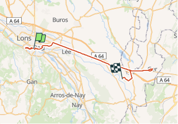

Length
46 km

Max alt
425 m

Uphill gradient
475 m
Km-Effort
52 km

Min alt
163 m

Downhill gradient
305 m
Boucle
No
Creation date :
2022-02-08 13:11:57.273
Updated on :
2022-02-08 17:13:26.43
1h35
Difficulty : Easy

FREE GPS app for hiking
 SityTrail
IGN / Geographical institutes
SityTrail Plus
The world is yours!
About
Trail Walking of 46 km to be discovered at New Aquitaine, Pyrénées-Atlantiques, Pau. This trail is proposed by LouisROGER.
Positioning
Country:
France
Region :
New Aquitaine
Department/Province :
Pyrénées-Atlantiques
Municipality :
Pau
Location:
Unknown
Start:(Dec)
Start:(UTM)
712399 ; 4796728 (30T) N.
Comments