


Tour Werentzhouse

ffdur
User
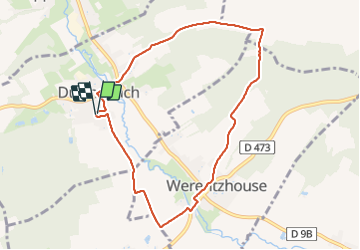

Length
8.1 km

Max alt
465 m

Uphill gradient
126 m
Km-Effort
9.8 km

Min alt
362 m

Downhill gradient
125 m
Boucle
Yes
Creation date :
2022-02-10 05:57:04.702
Updated on :
2022-02-10 08:14:23.85
2h12
Difficulty : Medium

FREE GPS app for hiking
 SityTrail
IGN / Geographical institutes
SityTrail Plus
The world is yours!
About
Trail Walking of 8.1 km to be discovered at Grand Est, Haut-Rhin, Durmenach. This trail is proposed by ffdur.
Positioning
Country:
France
Region :
Grand Est
Department/Province :
Haut-Rhin
Municipality :
Durmenach
Location:
Unknown
Start:(Dec)
Start:(UTM)
374910 ; 5264888 (32T) N.
Comments