Trail On foot Murnau am Staffelsee - Moosrundweg - Photo

Tous les sentiers balisés d’Europe PRO

© OpenStreetMap contributors
Length
Length
11.4 km
Max alt
Max alt
697 m
Uphill gradient
Uphill gradient
162 m
Km-Effort
Km-Effort  
13.6 km
Min alt
Min alt
621 m
Downhill gradient
Downhill gradient
162 m
Boucle
Boucle
Yes
Signpost
Signpost
Creation date :
2022-02-11 13:02:02.88
Updated on :
2022-02-11 13:02:02.88

(0 Reviews)

On foot
On foot
3h05
Difficulty : Easy

Scan this QR Code to open this trail in the SityTrail application

FREE GPS app for hiking

Logo SityTrail SityTrail

IGN / Geographical institutes

Download SityTrail from the App Store Download SityTrail from Google Play

Logo SityTrail SityTrail World

The world is yours!

Download SityTrail from the App Store Download SityTrail from Google Play Download SityTrail on Huawei AppGallery

About

Trail On foot of 11.4 km to be discovered at Bavaria, Landkreis Garmisch-Partenkirchen, Murnau am Staffelsee. This trail is proposed by SityTrail - itinéraires balisés pédestres.

Description

Trail created by Fremdenverkehrsamt Murnau.

Symbol: grünes Schild "Moosrundweg Nr. 5"

Photos

Positioning

Country:
Germany
Region :
Bavaria
Department/Province :
Landkreis Garmisch-Partenkirchen
Municipality :
Murnau am Staffelsee
Location:
Unknown
Start:(UTM)
661660 ; 5279185 (32T) N.

Trails nearby

Trail On foot Murnau am Staffelsee - Guglhör-Rundweg - Photo
On foot
PRO

On foot

Easy
Murnau am Staffelsee, Bavaria, Landkreis Garmisch-Partenkirchen, Germany
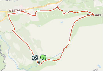
11.4 km | 14.7 km-effort
3h 19min
Yes


Close
My subscriptions