


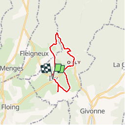
Le sentier du bois Talot

Geronimo2010
User

Length
9.3 km

Max alt
312 m

Uphill gradient
177 m
Km-Effort
11.7 km

Min alt
229 m

Downhill gradient
177 m
Boucle
Yes
Creation date :
2014-12-10 00:00:00.0
Updated on :
2014-12-10 00:00:00.0
2h16
Difficulty : Unknown

FREE GPS app for hiking
 SityTrail
IGN / Geographical institutes
SityTrail Plus
The world is yours!
About
Trail Walking of 9.3 km to be discovered at Grand Est, Ardennes, Illy. This trail is proposed by Geronimo2010.
Description
Le sentier du bois Talot
Photos

Positioning
Country:
France
Region :
Grand Est
Department/Province :
Ardennes
Municipality :
Illy
Location:
Unknown
Start:(Dec)
Start:(UTM)
641297 ; 5511074 (31U) N.
Comments