


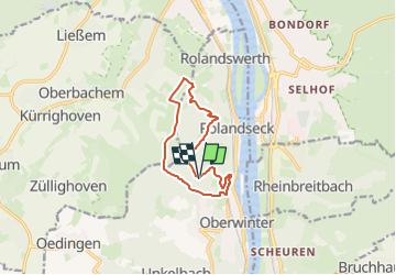

11.1 km | 14.1 km-effort
![Trail On foot Remagen - [5] Oberwinter Rundwanderweg - Photo](https://media.geolcdn.com/t/1900/400/ext.pjpeg?maxdim=2&url=https%3A%2F%2Fmedia.geolcdn.com%2Ff%2Ff5d36974-2dd7-4709-98b7-1c99706d0ead.jpeg)

Tous les sentiers balisés d’Europe PRO


FREE GPS app for hiking
 SityTrail
IGN / Geographical institutes
SityTrail World
The world is yours!
Trail On foot of 9.1 km to be discovered at Rhineland-Palatinate, Landkreis Ahrweiler, Remagen. This trail is proposed by SityTrail - itinéraires balisés pédestres.
Trail created by Verkehrs- und Verschönerungsverein Oberwinter-Rolandseck e.V..
Symbol: Schwarze 5 auf weißem Grund
![Trail On foot Remagen - [5] Oberwinter Rundwanderweg - Photo 1](https://media.geolcdn.com/t/2048/auto/2559eca4-887e-40f5-b3af-b96c18902a73.jpeg&format=jpg&maxdim=0 "Trail On foot Remagen - [5] Oberwinter Rundwanderweg - Photo 1")
![Trail On foot Remagen - [5] Oberwinter Rundwanderweg - Photo 2](https://media.geolcdn.com/t/2048/auto/ef486f30-294a-4739-94a0-e083fab54ff6.jpeg&format=jpg&maxdim=0 "Trail On foot Remagen - [5] Oberwinter Rundwanderweg - Photo 2")
![Trail On foot Remagen - [5] Oberwinter Rundwanderweg - Photo 3](https://media.geolcdn.com/t/2048/auto/1059f800-e229-40d0-b41a-932593a23b07.jpeg&format=jpg&maxdim=0 "Trail On foot Remagen - [5] Oberwinter Rundwanderweg - Photo 3")
![Trail On foot Remagen - [5] Oberwinter Rundwanderweg - Photo 4](https://media.geolcdn.com/t/2048/auto/13c52a15-7b6f-4a62-9b0b-1218e97d6675.jpeg&format=jpg&maxdim=0 "Trail On foot Remagen - [5] Oberwinter Rundwanderweg - Photo 4")
![Trail On foot Remagen - [5] Oberwinter Rundwanderweg - Photo 5](https://media.geolcdn.com/t/2048/auto/153feca6-d7d9-4a13-8e51-41c5baaf2e74.jpeg&format=jpg&maxdim=0 "Trail On foot Remagen - [5] Oberwinter Rundwanderweg - Photo 5")
![Trail On foot Remagen - [5] Oberwinter Rundwanderweg - Photo 6](https://media.geolcdn.com/t/2048/auto/5a473c51-803f-4687-bac7-f02fa39b2817.jpeg&format=jpg&maxdim=0 "Trail On foot Remagen - [5] Oberwinter Rundwanderweg - Photo 6")
![Trail On foot Remagen - [5] Oberwinter Rundwanderweg - Photo 7](https://media.geolcdn.com/t/2048/auto/f5d36974-2dd7-4709-98b7-1c99706d0ead.jpeg&format=jpg&maxdim=0 "Trail On foot Remagen - [5] Oberwinter Rundwanderweg - Photo 7")
![Trail On foot Remagen - [5] Oberwinter Rundwanderweg - Photo 8](https://media.geolcdn.com/t/2048/auto/eae2b70e-58fa-4b8f-9f4d-a9843b24202b.jpeg&format=jpg&maxdim=0 "Trail On foot Remagen - [5] Oberwinter Rundwanderweg - Photo 8")
![Trail On foot Remagen - [5] Oberwinter Rundwanderweg - Photo 9](https://media.geolcdn.com/t/2048/auto/e9a054a8-da4a-4a16-ac57-80bc03eb2784.jpeg&format=jpg&maxdim=0 "Trail On foot Remagen - [5] Oberwinter Rundwanderweg - Photo 9")
![Trail On foot Remagen - [5] Oberwinter Rundwanderweg - Photo 10](https://media.geolcdn.com/t/2048/auto/6664eb1c-7fe9-44b1-981a-c4e4f1e94796.jpeg&format=jpg&maxdim=0 "Trail On foot Remagen - [5] Oberwinter Rundwanderweg - Photo 10")
On foot
On foot
![Trail On foot Remagen - [4] Oberwinter Rundwanderweg - Photo](https://media.geolcdn.com/t/375/260/ext.jpg?maxdim=2&url=https%3A%2F%2Fmedia.geolcdn.com%2Ff%2Fe27ef9e9-090e-4d77-ab64-ebc2130b65b2.jpeg)
On foot
On foot
![Trail On foot Remagen - [1] Oberwinter Wanderweg (Oberwinter - Rolandseck) - Photo](https://media.geolcdn.com/t/375/260/ext.jpg?maxdim=2&url=https%3A%2F%2Fmedia.geolcdn.com%2Ff%2F25784967-1970-4af5-8d60-8f5ed7fdcfe9.jpeg)
On foot
On foot
On foot
On foot
On foot