


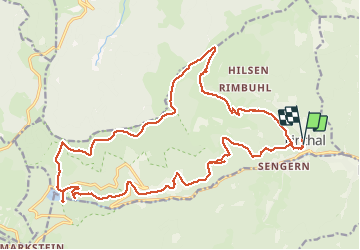
Linthal col Hilsenfirst Oberlauchen Lac de la Lauch

bob68
User

Length
25 km

Max alt
1267 m

Uphill gradient
1122 m
Km-Effort
40 km

Min alt
481 m

Downhill gradient
1126 m
Boucle
Yes
Creation date :
2014-12-10 00:00:00.0
Updated on :
2014-12-10 00:00:00.0
6h31
Difficulty : Very difficult

FREE GPS app for hiking
 SityTrail
IGN / Geographical institutes
SityTrail Plus
The world is yours!
About
Trail Walking of 25 km to be discovered at Grand Est, Haut-Rhin, Linthal. This trail is proposed by bob68.
Photos


Positioning
Country:
France
Region :
Grand Est
Department/Province :
Haut-Rhin
Municipality :
Linthal
Location:
Unknown
Start:(Dec)
Start:(UTM)
360229 ; 5312124 (32T) N.
Comments