


Fislis

ffdur
User

Length
11.6 km

Max alt
488 m

Uphill gradient
256 m
Km-Effort
15 km

Min alt
358 m

Downhill gradient
255 m
Boucle
Yes
Creation date :
2022-02-12 08:00:56.043
Updated on :
2022-02-12 10:48:30.693
1h03
Difficulty : Difficult

FREE GPS app for hiking
 SityTrail
IGN / Geographical institutes
SityTrail Plus
The world is yours!
About
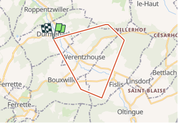
Trail Walking of 11.6 km to be discovered at Grand Est, Haut-Rhin, Durmenach. This trail is proposed by ffdur.
Positioning
Country:
France
Region :
Grand Est
Department/Province :
Haut-Rhin
Municipality :
Durmenach
Location:
Unknown
Start:(Dec)
Start:(UTM)
374915 ; 5264886 (32T) N.
Comments