


Soultz - Thierenbach par le nez de Soultz et Bildstokele

philvor
User
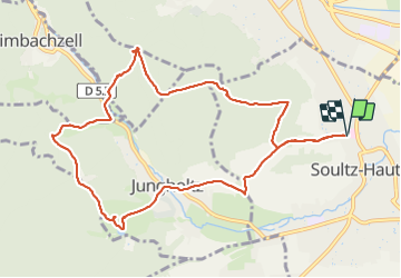

Length
11.1 km

Max alt
530 m

Uphill gradient
389 m
Km-Effort
16.3 km

Min alt
271 m

Downhill gradient
389 m
Boucle
Yes
Creation date :
2022-02-12 08:58:45.0
Updated on :
2022-02-12 14:32:40.853
3h00
Difficulty : Medium

FREE GPS app for hiking
 SityTrail
IGN / Geographical institutes
SityTrail Plus
The world is yours!
About
Trail Walking of 11.1 km to be discovered at Grand Est, Haut-Rhin, Soultz-Haut-Rhin. This trail is proposed by philvor.
Positioning
Country:
France
Region :
Grand Est
Department/Province :
Haut-Rhin
Municipality :
Soultz-Haut-Rhin
Location:
Unknown
Start:(Dec)
Start:(UTM)
367285 ; 5305663 (32T) N.
Comments