


Sur les sentiers de l'Ill Ensisheim

zazie
User
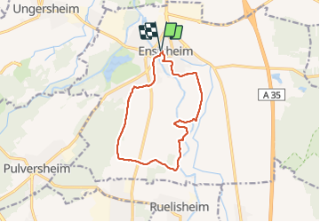

Length
11.9 km

Max alt
225 m

Uphill gradient
58 m
Km-Effort
12.6 km

Min alt
209 m

Downhill gradient
58 m
Boucle
Yes
Creation date :
2022-02-13 13:32:47.286
Updated on :
2022-02-13 16:00:08.716
2h23
Difficulty : Very easy

FREE GPS app for hiking
 SityTrail
IGN / Geographical institutes
SityTrail Plus
The world is yours!
About
Trail Walking of 11.9 km to be discovered at Grand Est, Haut-Rhin, Ensisheim. This trail is proposed by zazie.
Photos


Positioning
Country:
France
Region :
Grand Est
Department/Province :
Haut-Rhin
Municipality :
Ensisheim
Location:
Unknown
Start:(Dec)
Start:(UTM)
376707 ; 5302767 (32T) N.
Comments