Trail On foot Monteceneri - CH-Monte Ceneri - Monti di Spina di Sopra - Photo

CH-Monte Ceneri - Monti di Spina di Sopra

Tous les sentiers balisés d’Europe PRO

© OpenStreetMap contributors
Length
Length
4.5 km
Max alt
Max alt
1126 m
Uphill gradient
Uphill gradient
574 m
Km-Effort
Km-Effort  
10.6 km
Min alt
Min alt
553 m
Downhill gradient
Downhill gradient
105 m
Boucle
Boucle
No
Signpost
Signpost
Creation date :
2022-02-14 09:02:03.821
Updated on :
2022-02-14 09:02:03.821

(0 Reviews)

On foot
On foot
2h24
Difficulty : Easy

Scan this QR Code to open this trail in the SityTrail application

FREE GPS app for hiking

Logo SityTrail SityTrail

IGN / Geographical institutes

Download SityTrail from the App Store Download SityTrail from Google Play

Logo SityTrail SityTrail World

The world is yours!

Download SityTrail from the App Store Download SityTrail from Google Play Download SityTrail on Huawei AppGallery

About

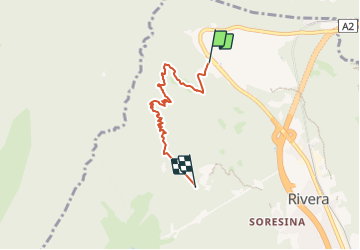
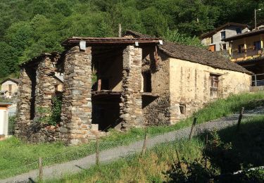
Trail On foot of 4.5 km to be discovered at Ticino, Distretto di Lugano, Monteceneri. This trail is proposed by SityTrail - itinéraires balisés pédestres.

Description

Monte Ceneri - Monti di Spina di Sopra

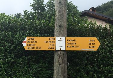
Symbol: bianco-rosso-bianco

Photos

Positioning

Country:
Switzerland
Region :
Ticino
Department/Province :
Distretto di Lugano
Municipality :
Monteceneri
Location:
Unknown
Start:(UTM)
492735 ; 5109523 (32T) N.

Trails nearby

Trail On foot Gambarogno - Bruno - Quartino - Photo
On foot
PRO

On foot

Easy
Gambarogno, Ticino, Distretto di Locarno, Switzerland
3.7 km | 6.1 km-effort
1h 23min
No
Trail On foot Gambarogno - Magadino - Ponte Fiume Ticino Quartino - Photo
On foot
PRO

On foot

Easy
Gambarogno, Ticino, Distretto di Locarno, Switzerland
3.2 km | 3.5 km-effort
47min
No
Trail On foot Gambarogno - Orgnana - Quartino - Photo
On foot
PRO

On foot

Easy
Gambarogno, Ticino, Distretto di Locarno, Switzerland
3.1 km | 4 km-effort
54min
No
Trail On foot Monteceneri - CH-Monte Ceneri - Alpe Foppa - Photo
On foot
PRO

On foot

Easy
Monteceneri, Ticino, Distretto di Lugano, Switzerland
6.1 km | 15.9 km-effort
3h 36min
No
Trail On foot Monteceneri - CH-Alpe Foppa - Piano di Mora - Photo
On foot
PRO

On foot

Easy
Monteceneri, Ticino, Distretto di Lugano, Switzerland
3.6 km | 4.9 km-effort
1h 7min
No
Trail On foot Monteceneri - Isone-Gola di Lago - Photo
On foot
PRO

On foot

Easy
Monteceneri, Ticino, Distretto di Lugano, Switzerland
4.7 km | 6.9 km-effort
1h 33min
No
Trail On foot Monteceneri - Gola di Lago-Condra - Photo
On foot
PRO

On foot

Easy
Monteceneri, Ticino, Distretto di Lugano, Switzerland
3.5 km | 5.2 km-effort
1h 11min
No
Trail Walking Monteceneri - ticino_test - Photo
Walking
GUIDE+

Walking

Very easy
Monteceneri, Ticino, Distretto di Lugano, Switzerland
21 km | 32 km-effort
Unknown
No
Trail Mountain bike Monteceneri - Bike32930 - Photo
Mountain bike
GUIDE+

Mountain bike

Very easy
Monteceneri, Ticino, Distretto di Lugano, Switzerland
41 km | 64 km-effort
Unknown
Yes


Close
My subscriptions