Trail On foot Ribeirinha - Ribeirinha - Photo

Tous les sentiers balisés d’Europe PRO

© OpenStreetMap contributors
Length
Length
8 km
Max alt
Max alt
388 m
Uphill gradient
Uphill gradient
442 m
Km-Effort
Km-Effort  
13.9 km
Min alt
Min alt
8 m
Downhill gradient
Downhill gradient
447 m
Boucle
Boucle
Yes
Signpost
Signpost
Creation date :
2022-02-14 15:17:32.391
Updated on :
2022-02-14 15:17:32.391

(0 Reviews)

On foot
On foot
3h09
Difficulty : Easy

Scan this QR Code to open this trail in the SityTrail application

FREE GPS app for hiking

Logo SityTrail SityTrail

IGN / Geographical institutes

Download SityTrail from the App Store Download SityTrail from Google Play

Logo SityTrail SityTrail World

The world is yours!

Download SityTrail from the App Store Download SityTrail from Google Play Download SityTrail on Huawei AppGallery

About

Trail On foot of 8 km to be discovered at Azores, Unknown, Ribeirinha. This trail is proposed by SityTrail - itinéraires balisés pédestres.

Description

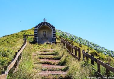
This circular route in the village of Ribeirinha evolves partially in the protected area for habitats and species management of Lomba Grande and the Graben of Pedro Miguel, one of the main Geosites of the Archipelago. Also known as the volcanic complex of Ribeirinha, represents the oldest part of the island with around 800 thousand years. Begin the trail in the center of the

Website: http://trails.visitazores.com/en/trails-azores/faial/ribeirinha

Photos

Positioning

Country:
Portugal
Region :
Azores
Department/Province :
Unknown
Municipality :
Ribeirinha
Location:
Unknown
Start:(UTM)
359143 ; 4273372 (26S) N.

Trails nearby

Trail On foot  - Caminhos Velhos - Photo
On foot
PRO

On foot

Medium
, Azores, , Portugal
15.6 km | 28 km-effort
6h 15min
No


Close
My subscriptions