Trail On foot Candedo - Trilho do Tinhela - Photo

Trilho do Tinhela

Tous les sentiers balisés d’Europe PRO

© OpenStreetMap contributors
Length
Length
8.8 km
Max alt
Max alt
487 m
Uphill gradient
Uphill gradient
362 m
Km-Effort
Km-Effort  
13.7 km
Min alt
Min alt
172 m
Downhill gradient
Downhill gradient
370 m
Boucle
Boucle
No
Signpost
Signpost
Creation date :
2022-02-14 15:23:07.723
Updated on :
2022-02-14 15:23:07.723

(0 Reviews)

On foot
On foot
3h06
Difficulty : Easy

Scan this QR Code to open this trail in the SityTrail application

FREE GPS app for hiking

Logo SityTrail SityTrail

IGN / Geographical institutes

Download SityTrail from the App Store Download SityTrail from Google Play

Logo SityTrail SityTrail World

The world is yours!

Download SityTrail from the App Store Download SityTrail from Google Play Download SityTrail on Huawei AppGallery

About

Trail On foot of 8.8 km to be discovered at North, Vila Real, Candedo. This trail is proposed by SityTrail - itinéraires balisés pédestres.

Description

Trail created by Parque Natural Regional do Vale do Tua.


Website: https://www.cm-murca.pt/frontoffice/pages/713

Photos

Positioning

Country:
Portugal
Region :
North
Department/Province :
Vila Real
Municipality :
Candedo
Location:
Unknown
Start:(UTM)
636373 ; 4576637 (29T) N.

Trails nearby

Trail On foot Abreiro - Trilho da Sobreira – Casa da Floresta – Porrais - Photo
On foot
PRO

On foot

Medium
Abreiro, North, Bragança District, Portugal
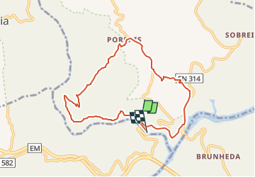
14.7 km | 23 km-effort
5h 9min
Yes


Close
My subscriptions