


Sentiero 8C - Bayet Superiore(1.842)-La Rossa Superiore (2.295) - E - 1h40' - disl. 417

SityTrail - itinéraires balisés pédestres
Tous les sentiers balisés d’Europe GUIDE+
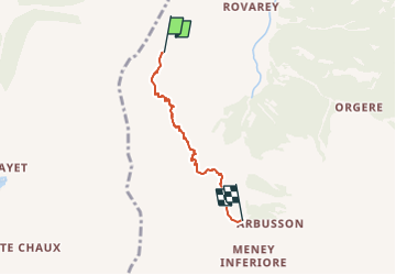

Length
3.4 km

Max alt
2381 m

Uphill gradient
214 m
Km-Effort
7.4 km

Min alt
1858 m

Downhill gradient
549 m
Boucle
No

Signpost
Creation date :
2022-02-15 05:14:21.893
Updated on :
2022-03-01 03:06:31.99
1h40
Difficulty : Easy

FREE GPS app for hiking
 SityTrail
IGN / Geographical institutes
SityTrail Plus
The world is yours!
About
Trail On foot of 3.4 km to be discovered at Aosta Valley, Unknown, Fénis. This trail is proposed by SityTrail - itinéraires balisés pédestres.
Positioning
Country:
Italy
Region :
Aosta Valley
Department/Province :
Unknown
Municipality :
Fénis
Location:
Unknown
Start:(Dec)
Start:(UTM)
381383 ; 5059088 (32T) N.
Comments