


Sentiero 5C - Cuneu-Col Fussy

SityTrail - itinéraires balisés pédestres
Tous les sentiers balisés d’Europe GUIDE+

Length
3.2 km

Max alt
2918 m

Uphill gradient
0 m
Km-Effort
5.7 km

Min alt
2148 m

Downhill gradient
756 m
Boucle
No

Signpost
Creation date :
2022-02-15 05:21:45.946
Updated on :
2022-03-01 03:34:47.568
1h18
Difficulty : Easy

FREE GPS app for hiking
 SityTrail
IGN / Geographical institutes
SityTrail Plus
The world is yours!
About
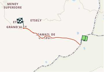
Trail On foot of 3.2 km to be discovered at Aosta Valley, Unknown, Champorcher. This trail is proposed by SityTrail - itinéraires balisés pédestres.
Photos

Positioning
Country:
Italy
Region :
Aosta Valley
Department/Province :
Unknown
Municipality :
Champorcher
Location:
Unknown
Start:(Dec)
Start:(UTM)
385637 ; 5053654 (32T) N.
Comments