Trail On foot Aiglun - Traversée de l'Estéron - Etape 3 - Photo

Traversée de l'Estéron - Etape 3

Tous les sentiers balisés d’Europe PRO

© OpenStreetMap contributors
Length
Length
16.7 km
Max alt
Max alt
1167 m
Uphill gradient
Uphill gradient
1179 m
Km-Effort
Km-Effort  
33 km
Min alt
Min alt
532 m
Downhill gradient
Downhill gradient
1269 m
Boucle
Boucle
No
Signpost
Signpost
Creation date :
2022-02-15 18:39:37.025
Updated on :
2022-03-02 21:25:28.176

(0 Reviews)

On foot
On foot
7h26
Difficulty : Difficult

Scan this QR Code to open this trail in the SityTrail application

FREE GPS app for hiking

Logo SityTrail SityTrail

IGN / Geographical institutes

Download SityTrail from the App Store Download SityTrail from Google Play

Logo SityTrail SityTrail World

The world is yours!

Download SityTrail from the App Store Download SityTrail from Google Play Download SityTrail on Huawei AppGallery

About

Trail On foot of 16.7 km to be discovered at Provence-Alpes-Côte d'Azur, Maritime Alps, Aiglun. This trail is proposed by SityTrail - itinéraires balisés pédestres.

Description

Randonnée pédestre - Au départ de Gourdon, Pont du Loup (188 m)

Website: https://randoxygene.departement06.fr/traversees/traversee-de-l-esteron-prealpes-de-grasse-17770.html

Photos

Positioning

Country:
France
Region :
Provence-Alpes-Côte d'Azur
Department/Province :
Maritime Alps
Municipality :
Aiglun
Location:
Unknown
Start:(UTM)
332412 ; 4858181 (32T) N.

Trails nearby

Trail On foot Le Mas - Grand tour du haut Estéron - Etape 3 - Photo
On foot
PRO

On foot

Medium
Le Mas, Provence-Alpes-Côte d'Azur, Maritime Alps, France
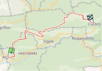
12.1 km | 25 km-effort
5h 35min
No
Trail On foot Sigale - Circuit de la Cacia - Photo
On foot
PRO

On foot

Easy
Sigale, Provence-Alpes-Côte d'Azur, Maritime Alps, France
9.6 km | 18.7 km-effort
4h 15min
Yes
Trail On foot Gréolières - Cime du Cheiron - Photo
On foot
PRO

On foot

Easy
Gréolières, Provence-Alpes-Côte d'Azur, Maritime Alps, France
5.9 km | 8.9 km-effort
2h 1min
No
Trail On foot Le Mas - Montagne de Charamel - Photo
On foot
PRO

On foot

Medium
Le Mas, Provence-Alpes-Côte d'Azur, Maritime Alps, France
12.2 km | 24 km-effort
5h 29min
Yes
Trail Walking Sigale - Cime CACCIA, SIGALE (06) - Photo
Walking
ch2slv

Walking

Medium
(1)
Sigale, Provence-Alpes-Côte d'Azur, Maritime Alps, France
9.3 km | 17.7 km-effort
3h 42min
Yes
Trail Walking Sigale - Sigale, Cime Caccia, Clue Riolan - Photo
Walking
GrouGary

Walking

Easy
Sigale, Provence-Alpes-Côte d'Azur, Maritime Alps, France
10.9 km | 20 km-effort
3h 44min
Yes
Trail Walking Gréolières - Gréolières les Neiges - Collet de Barri- Cime du Cheiron - Croix de Verse - Combe d'Henry - Photo
Walking
LtZIP

Walking

Difficult
Gréolières, Provence-Alpes-Côte d'Azur, Maritime Alps, France
21 km | 33 km-effort
5h 47min
Yes
Trail On foot Sallagriffon - Mont Saint-Martin - Photo
On foot
PRO

On foot

Easy
Sallagriffon, Provence-Alpes-Côte d'Azur, Maritime Alps, France
9.4 km | 17 km-effort
3h 51min
Yes
Trail Snowshoes Gréolières - GREOLIERES - Photo
Snowshoes
Daniel Benteux

Snowshoes

Easy
Gréolières, Provence-Alpes-Côte d'Azur, Maritime Alps, France
5.9 km | 8 km-effort
1h 56min
Yes


Close
My subscriptions