Trail On foot Bischoffsheim - Circuit des Balcons - Photo

Circuit des Balcons

Tous les sentiers balisés d’Europe PRO

© OpenStreetMap contributors
Length
Length
12.4 km
Max alt
Max alt
314 m
Uphill gradient
Uphill gradient
227 m
Km-Effort
Km-Effort  
15.4 km
Min alt
Min alt
171 m
Downhill gradient
Downhill gradient
229 m
Boucle
Boucle
Yes
Signpost
Signpost
Creation date :
2022-02-15 19:44:56.431
Updated on :
2022-03-03 00:22:04.792

(1 Reviews)

On foot
On foot
3h30
Difficulty : Easy

Scan this QR Code to open this trail in the SityTrail application

FREE GPS app for hiking

Logo SityTrail SityTrail

IGN / Geographical institutes

Download SityTrail from the App Store Download SityTrail from Google Play

Logo SityTrail SityTrail World

The world is yours!

Download SityTrail from the App Store Download SityTrail from Google Play Download SityTrail on Huawei AppGallery

About

Trail On foot of 12.4 km to be discovered at Grand Est, Bas-Rhin, Bischoffsheim. This trail is proposed by SityTrail - itinéraires balisés pédestres.

Description

Trail created by Club Vosgien Rosheim.

Photos

Positioning

Country:
France
Region :
Grand Est
Department/Province :
Bas-Rhin
Municipality :
Bischoffsheim
Location:
Unknown
Start:(UTM)
388359 ; 5372268 (32U) N.

Comments

Please log in to post a review or rate the element


Belle balade facile dans les vignes. Le ➕, la découverte d'une magnifique petite ville alsacienne.


Trails nearby

Trail Walking Mutzig - Les sanctuaires autour de Mutzig - Photo
Walking
VacheKiri67

Walking

Medium
(1)
Mutzig, Grand Est, Bas-Rhin, France
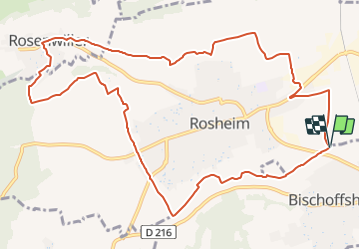
13.6 km | 17.9 km-effort
5h 0min
Yes
Trail Walking Ottrott - Le Mont Sainte-Odile depuis Otrott - Photo
Walking
VacheKiri67

Walking

Medium
(1)
Ottrott, Grand Est, Bas-Rhin, France
13 km | 20 km-effort
6h 18min
Yes
Trail Walking Mutzig - Les sanctuaires autour de Mutzig - Photo
Walking
tracegps

Walking

Difficult
(1)
Mutzig, Grand Est, Bas-Rhin, France
12.7 km | 16.8 km-effort
4h 0min
Yes
Trail Walking Dorlisheim - Escapade dans le vignoble de Dorlisheim - Photo
Walking
tracegps

Walking

Medium
(1)
Dorlisheim, Grand Est, Bas-Rhin, France
9.7 km | 12.6 km-effort
3h 0min
Yes
Trail Walking Mutzig - Autour du Fort de Mutzig - Photo
Walking
VacheKiri67

Walking

Difficult
(2)
Mutzig, Grand Est, Bas-Rhin, France
18.7 km | 26 km-effort
6h 30min
Yes
Trail Walking Obernai - Obernai gare - Mont St Odile - Photo
Walking
tracegps

Walking

Difficult
(2)
Obernai, Grand Est, Bas-Rhin, France
20 km | 29 km-effort
5h 0min
Yes
Trail Mountain bike Ottrott - Sainte-Odile East-Face - Photo
Mountain bike
tracegps

Mountain bike

Difficult
(1)
Ottrott, Grand Est, Bas-Rhin, France
24 km | 39 km-effort
3h 0min
Yes
Trail On foot Rosheim - Circuit du Vignoble - Photo
On foot
PRO

On foot

Easy
Rosheim, Grand Est, Bas-Rhin, France
8.8 km | 11.7 km-effort
2h 38min
Yes
Trail Mountain bike Rosheim - schnacker tour le grand 8 circuit magique - Photo
Mountain bike
raphnou

Mountain bike

Difficult
(1)
Rosheim, Grand Est, Bas-Rhin, France
29 km | 39 km-effort
2h 30min
Yes


Close
My subscriptions