![](/images/other/stat-length.png)
![Trail Walking Vercheny - Chateau de Barry, Gaudichart et les cretes - Photo](https://media.geolcdn.com/t/1900/400/ext.pjpeg?maxdim=2&url=https%3A%2F%2Fmedia.geolcdn.com%2Ff%2F56225018-4f93-460e-b366-5b13ec1744cf.jpg)
Chateau de Barry, Gaudichart et les cretes
ajd26
User
![Length](/images/other/stat-length.png)
Length
11.8 km
![Max alt](https://static1.geolcdn.com/siteimages/upload/files/1508320355ic_sort_altitude_max_24dp.png)
Max alt
1075 m
![Uphill gradient](https://static1.geolcdn.com/siteimages/upload/files/1508320355ic_sort_den_pos_24dp.png)
Uphill gradient
701 m
![Km-Effort](/images/other/stat-length.png)
Km-Effort
21 km
![Min alt](https://static1.geolcdn.com/siteimages/upload/files/1508320355ic_sort_altitude_min_24dp.png)
Min alt
428 m
![Downhill gradient](https://static1.geolcdn.com/siteimages/upload/files/1508320355ic_sort_den_neg_24dp.png)
Downhill gradient
701 m
![Boucle](https://static1.geolcdn.com/siteimages/upload/files/16400158638029165_repeat_loop_refresh_sync_direction_icon.png)
Boucle
Yes
Creation date :
2022-02-17 08:09:37.0
Updated on :
2022-02-18 08:35:05.887
![Walking](https://static1.geolcdn.com/sitytour/trail-icons/101.png)
4h10
Difficulty : Medium
![Scan this QR Code to open this trail in the SityTrail application](https://capi.geolives.com/qq0zvz2zws4bq2lad0pu/sitytour/trails/3131964/qr.png?size=200)
FREE GPS app for hiking
About
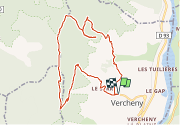
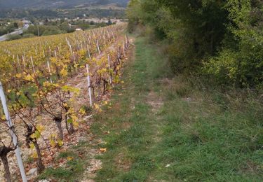
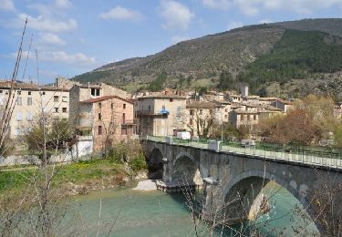
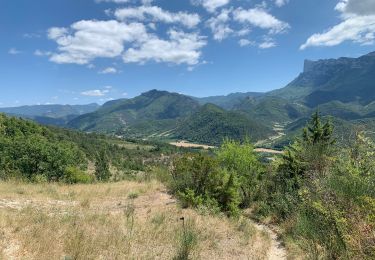
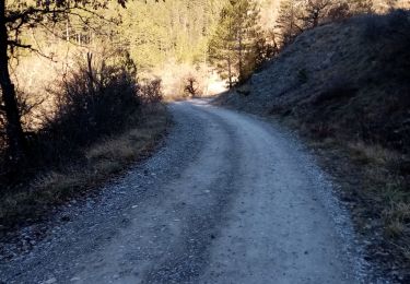
Trail Walking of 11.8 km to be discovered at Auvergne-Rhône-Alpes, Drôme, Vercheny. This trail is proposed by ajd26.
Description
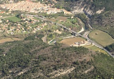
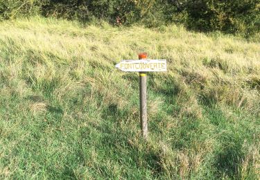
départ Vercheny le Haut, chateau du Barry, Gaudichart et retour par les crêtes avec jolis panoramas sur vallée de la Drome et le Vercors
sur les crêtes, la trace est visible et il faut qlq fois mettre les mains mais rien de vertigineux ou dangereux
Positioning
Country:
France
Region :
Auvergne-Rhône-Alpes
Department/Province :
Drôme
Municipality :
Vercheny
Location:
Unknown
Start:(Dec)
Start:(UTM)
678318 ; 4953335 (31T) N.
Comments
Trails nearby
![Trail Walking Vercheny - Vercheny Chateau du Barry 14 km - Photo](https://media.geolcdn.com/t/375/260/ext.jpg?maxdim=2&url=https%3A%2F%2Fmedia.geolcdn.com%2Ff%2F519ec2eb-eec0-4702-a29a-2c5cd69166ae.jpg)
![Walking Walking](https://static1.geolcdn.com/sitytour/trail-icons/101.png)
Vercheny Chateau du Barry 14 km
Walking
Medium
(1)
Vercheny,
Auvergne-Rhône-Alpes,
Drôme,
France
![](/images/other/stat-length.png)
14.2 km | 23 km-effort
5h 11min
![](https://static1.geolcdn.com/siteimages/upload/files/16400158638029165_repeat_loop_refresh_sync_direction_icon.png)
Yes
![Trail Mountain bike Saillans - Grande Traversée des PréAlpes à VTT : variante Saillans - Montmorin - Photo](https://media.geolcdn.com/t/375/260/ext.jpg?maxdim=2&url=https%3A%2F%2Fservices.sitytrail.com%2FGeolivesWS%2FDownloadMedia.ashx%3FTrailID%3D102178%26Media%3D2569_1.jpg)
![Mountain bike Mountain bike](https://static1.geolcdn.com/sitytour/trail-icons/202.png)
Grande Traversée des PréAlpes à VTT : variante Saillans - Montmorin
Mountain bike
Very difficult
(1)
Saillans,
Auvergne-Rhône-Alpes,
Drôme,
France
![](/images/other/stat-length.png)
74 km | 113 km-effort
11h 0min
![](https://static1.geolcdn.com/siteimages/upload/files/16400158638029165_repeat_loop_refresh_sync_direction_icon.png)
No
![Trail Walking Aurel - Vercors - Vercheny Combe Noire - Photo](https://media.geolcdn.com/t/375/260/ext.jpg?maxdim=2&url=https%3A%2F%2Fstatic1.geolcdn.com%2Fsiteimages%2Fupload%2Ffiles%2F1553511878bg_sport_marche.png)
![Walking Walking](https://static1.geolcdn.com/sitytour/trail-icons/101.png)
Vercors - Vercheny Combe Noire
Walking
Very easy
(1)
Aurel,
Auvergne-Rhône-Alpes,
Drôme,
France
![](/images/other/stat-length.png)
8.7 km | 12.7 km-effort
2h 55min
![](https://static1.geolcdn.com/siteimages/upload/files/16400158638029165_repeat_loop_refresh_sync_direction_icon.png)
Yes
![Trail Walking Saillans - Cresta - Photo](https://media.geolcdn.com/t/375/260/ext.jpg?maxdim=2&url=https%3A%2F%2Fmedia.geolcdn.com%2Ff%2Fdda4974b-08c2-4620-b53f-ea2254640dae.jpg)
![Walking Walking](https://static1.geolcdn.com/sitytour/trail-icons/101.png)
Cresta
Walking
Very difficult
Saillans,
Auvergne-Rhône-Alpes,
Drôme,
France
![](/images/other/stat-length.png)
14 km | 27 km-effort
6h 12min
![](https://static1.geolcdn.com/siteimages/upload/files/16400158638029165_repeat_loop_refresh_sync_direction_icon.png)
Yes
![Trail Walking Aurel - Butte de l'Aigle - Photo](https://media.geolcdn.com/t/375/260/ext.jpg?maxdim=2&url=https%3A%2F%2Fmedia.geolcdn.com%2Ff%2F93f8cc31-cdb7-4c51-ac3c-2c9d3f413282.jpg)
![Walking Walking](https://static1.geolcdn.com/sitytour/trail-icons/101.png)
Butte de l'Aigle
Walking
Medium
(1)
Aurel,
Auvergne-Rhône-Alpes,
Drôme,
France
![](/images/other/stat-length.png)
13.5 km | 24 km-effort
4h 37min
![](https://static1.geolcdn.com/siteimages/upload/files/16400158638029165_repeat_loop_refresh_sync_direction_icon.png)
Yes
![Trail Walking Saillans - 26 gaudichard zel - Photo](https://media.geolcdn.com/t/375/260/ext.jpg?maxdim=2&url=https%3A%2F%2Fmedia.geolcdn.com%2Ff%2Fb5e022d8-7c23-4271-85bc-1b741ca6ca0c.jpg)
![Walking Walking](https://static1.geolcdn.com/sitytour/trail-icons/101.png)
26 gaudichard zel
Walking
Medium
Saillans,
Auvergne-Rhône-Alpes,
Drôme,
France
![](/images/other/stat-length.png)
18.2 km | 32 km-effort
7h 42min
![](https://static1.geolcdn.com/siteimages/upload/files/16400158638029165_repeat_loop_refresh_sync_direction_icon.png)
Yes
![Trail Walking Saillans - Saillans Chapelle St Christophe 14km. - Photo](https://media.geolcdn.com/t/375/260/ext.jpg?maxdim=2&url=https%3A%2F%2Fmedia.geolcdn.com%2Ff%2Fdbc3dc28-619e-4ea9-9959-103bf755836c.jpg)
![Walking Walking](https://static1.geolcdn.com/sitytour/trail-icons/101.png)
Saillans Chapelle St Christophe 14km.
Walking
Medium
Saillans,
Auvergne-Rhône-Alpes,
Drôme,
France
![](/images/other/stat-length.png)
14.1 km | 20 km-effort
4h 42min
![](https://static1.geolcdn.com/siteimages/upload/files/16400158638029165_repeat_loop_refresh_sync_direction_icon.png)
Yes
![Trail Walking Saillans - Grande boucle au départ de Saillans - Photo](https://media.geolcdn.com/t/375/260/ext.jpg?maxdim=2&url=https%3A%2F%2Fmedia.geolcdn.com%2Ff%2Fa7f6ee47-9dee-488a-8459-0b79be140170.jpg)
![Walking Walking](https://static1.geolcdn.com/sitytour/trail-icons/101.png)
Grande boucle au départ de Saillans
Walking
Difficult
Saillans,
Auvergne-Rhône-Alpes,
Drôme,
France
![](/images/other/stat-length.png)
32 km | 45 km-effort
8h 0min
![](https://static1.geolcdn.com/siteimages/upload/files/16400158638029165_repeat_loop_refresh_sync_direction_icon.png)
Yes
![Trail Walking Saillans - Le Serre des 3 Bornes - Photo](https://media.geolcdn.com/t/375/260/ext.jpg?maxdim=2&url=https%3A%2F%2Fmedia.geolcdn.com%2Ff%2Fe90724a4-5305-4622-8eb1-7c4503267abc.jpg)
![Walking Walking](https://static1.geolcdn.com/sitytour/trail-icons/101.png)
Le Serre des 3 Bornes
Walking
Medium
(1)
Saillans,
Auvergne-Rhône-Alpes,
Drôme,
France
![](/images/other/stat-length.png)
14.8 km | 21 km-effort
3h 46min
![](https://static1.geolcdn.com/siteimages/upload/files/16400158638029165_repeat_loop_refresh_sync_direction_icon.png)
Yes