


lac la Valette

chanac les mines
User
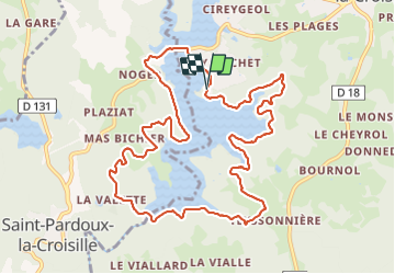

Length
12.3 km

Max alt
541 m

Uphill gradient
251 m
Km-Effort
15.6 km

Min alt
472 m

Downhill gradient
251 m
Boucle
Yes
Creation date :
2022-02-17 12:30:47.355
Updated on :
2022-02-17 17:43:40.224
3h55
Difficulty : Difficult

FREE GPS app for hiking
 SityTrail
IGN / Geographical institutes
SityTrail Plus
The world is yours!
About
Trail Walking of 12.3 km to be discovered at New Aquitaine, Corrèze, Marcillac-la-Croisille. This trail is proposed by chanac les mines.
Positioning
Country:
France
Region :
New Aquitaine
Department/Province :
Corrèze
Municipality :
Marcillac-la-Croisille
Location:
Unknown
Start:(Dec)
Start:(UTM)
421990 ; 5012502 (31T) N.
Comments
impossible à suivre
dommage qu'on perde le chemin dans les bois à plusieurs reprises. sinon très belle rando.