


Lameysberg

LaurentGILG
User
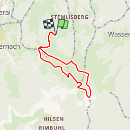

Length
12.8 km

Max alt
1266 m

Uphill gradient
576 m
Km-Effort
21 km

Min alt
862 m

Downhill gradient
576 m
Boucle
Yes
Creation date :
2019-01-20 20:50:44.716
Updated on :
2019-01-20 20:50:44.735
5h48
Difficulty : Medium

FREE GPS app for hiking
 SityTrail
IGN / Geographical institutes
SityTrail Plus
The world is yours!
About
Trail Walking of 12.8 km to be discovered at Grand Est, Haut-Rhin, Breitenbach-Haut-Rhin. This trail is proposed by LaurentGILG.
Positioning
Country:
France
Region :
Grand Est
Department/Province :
Haut-Rhin
Municipality :
Breitenbach-Haut-Rhin
Location:
Unknown
Start:(Dec)
Start:(UTM)
359109 ; 5318276 (32U) N.
Comments